Approximate Location Map
Large Map »
Latitude: 51.5235 / 51°31'24"N
Longitude: -1.1448 / 1°8'41"W
OS Eastings: 459426
OS Northings: 180854
OS Grid: SU594808
Mapcode National: GBR 91Z.KC6
Mapcode Global: VHCYW.3YMZ
Plus Code: 9C3WGVF4+93
Entry Name: Chest Tomb Approximately 12 Metres to South West of Tower of Church of St Mary
Listing Date: 29 November 1983
Grade: II
Source: Historic England
Source ID: 1213386
English Heritage Legacy ID: 397963
ID on this website: 101213386
Location: St Mary's Church, Streatley, West Berkshire, RG8
County: West Berkshire
Civil Parish: Streatley
Built-Up Area: Streatley
Traditional County: Berkshire
Lieutenancy Area (Ceremonial County): Berkshire
Tagged with: Chest tomb
STREATLEY HIGH STREET (north side)
SU 5980
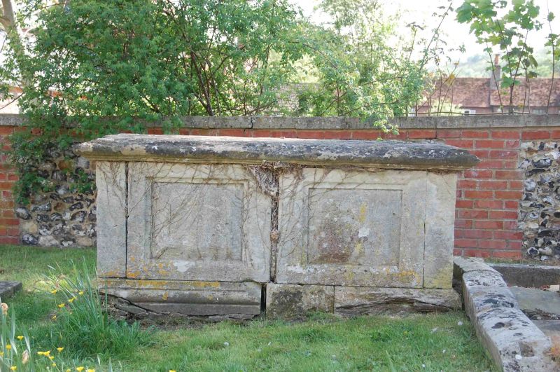
10/11 Chest Tomb Approximately
12 Metres To South-west
Of Tower Of Church Of
St. Mary
GV II
Chest tomb. C18. Ashlar with moulded base and top. 2 fielded panels on
each side and one at each end. Inscription illegible at time of resurvey.
Included for group value.
Listing NGR: SU5942680854
External links are from the relevant listing authority and, where applicable, Wikidata. Wikidata IDs may be related buildings as well as this specific building. If you want to add or update a link, you will need to do so by editing the Wikidata entry.


Other nearby listed buildings
