Approximate Location Map
Large Map »
Latitude: 54.0532 / 54°3'11"N
Longitude: -2.8049 / 2°48'17"W
OS Eastings: 347402
OS Northings: 462219
OS Grid: SD474622
Mapcode National: GBR 8PVK.JS
Mapcode Global: WH846.WDH2
Plus Code: 9C6V353W+72
Entry Name: Bruntons Warehouse (South Eastern Part Only)
Listing Date: 13 March 1995
Grade: II
Source: Historic England
Source ID: 1213894
English Heritage Legacy ID: 383308
ID on this website: 101213894
Location: Lancaster, Lancashire, LA1
County: Lancashire
District: Lancaster
Electoral Ward/Division: Castle
Parish: Non Civil Parish
Built-Up Area: Lancaster
Traditional County: Lancashire
Lieutenancy Area (Ceremonial County): Lancashire
Church of England Parish: Lancaster St Mary with St John and St Anne
Church of England Diocese: Blackburn
Tagged with: Architectural structure
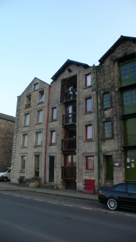
LANCASTER
SD4762 ST GEORGE'S QUAY
1685-1/3/273 (South West side)
Brunton's Warehouse (south-eastern
part only)
GV II
Warehouses, now flats. Mid C18, converted and altered c1980.
Coursed squared sandstone with ashlar dressings and slate
roof, with the gable to the road and a projecting verge over
the central part of the width. Approx 15m deep on plan behind
a facade which is approx 6m wide.
4 storeys above a cellar, which has a blocked opening to the
right. Chamfered quoins. Central loading slot, now with
balconies on each floor, which has a plain stone surround. The
other windows have similar surrounds, and glazing of c1980.
The left-hand window on the top floor was also inserted at
this time. The left-hand window on the ground floor is set
within a blocked door surround.
The warehouse to the right, on the corner of Duke Street and
now part of the same block of flats, has a facade which was
drastically altered and is not included.
Listing NGR: SD4740262219
External links are from the relevant listing authority and, where applicable, Wikidata. Wikidata IDs may be related buildings as well as this specific building. If you want to add or update a link, you will need to do so by editing the Wikidata entry.


Other nearby listed buildings
