Approximate Location Map
Large Map »
Latitude: 54.4023 / 54°24'8"N
Longitude: -0.9317 / 0°55'53"W
OS Eastings: 469450
OS Northings: 501283
OS Grid: NZ694012
Mapcode National: GBR PKYJ.3N
Mapcode Global: WHF91.NMK0
Plus Code: 9C6XC329+W8
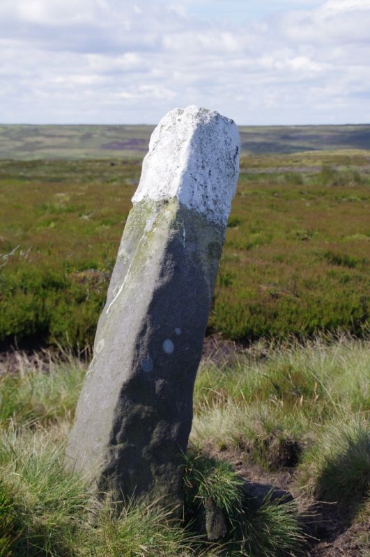
Entry Name: Boundary Stone
Listing Date: 27 August 1987
Grade: II
Source: Historic England
Source ID: 1213905
English Heritage Legacy ID: 382483
ID on this website: 101213905
Location: North Yorkshire, YO21
County: North Yorkshire
District: Scarborough
Civil Parish: Rosedale East Side
Traditional County: Yorkshire
Lieutenancy Area (Ceremonial County): North Yorkshire
Tagged with: Boundary marker
ROSEDALE EAST SIDE ROSEDALE HEAD ROAD
NZ 60 SE
(south-west side, off)
1/65 Boundary stone
- II
Boundary stone. Early Cl9. Roughly-tooled sandstone. Rectangular post
with whitewashed top, approximately 1.3 metres high. North-east face
inscribed "D" for Danby parish; south-west face has "R" for Rosedale parish.
Listing NGR: NZ6944901282
External links are from the relevant listing authority and, where applicable, Wikidata. Wikidata IDs may be related buildings as well as this specific building. If you want to add or update a link, you will need to do so by editing the Wikidata entry.


Other nearby listed buildings
