Approximate Location Map
Large Map »
Latitude: 52.0368 / 52°2'12"N
Longitude: -1.8518 / 1°51'6"W
OS Eastings: 410260
OS Northings: 237608
OS Grid: SP102376
Mapcode National: GBR 3M7.6N5
Mapcode Global: VHB17.V2CF
Plus Code: 9C4W24PX+P7
Entry Name: Bankside
Listing Date: 30 July 1959
Grade: II
Source: Historic England
Source ID: 1214943
English Heritage Legacy ID: 399609
ID on this website: 101214943
Location: Broadway, Wychavon, Worcestershire, WR12
County: Worcestershire
District: Wychavon
Civil Parish: Broadway
Built-Up Area: Broadway
Traditional County: Worcestershire
Lieutenancy Area (Ceremonial County): Worcestershire
Church of England Parish: Broadway
Church of England Diocese: Worcester
Tagged with: Building
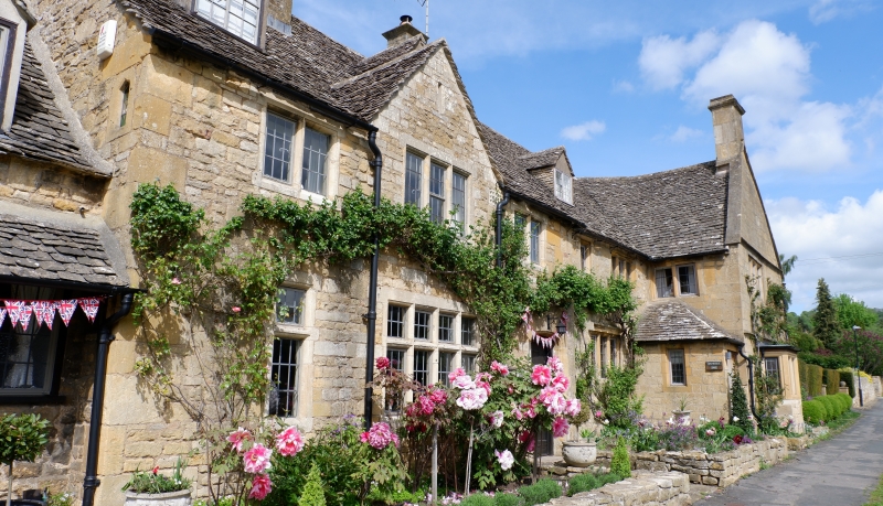
SP 1037 BROADWAY CP HIGH STREET (north side)
9/61 No 140 (Bankside)
30.7.59
GV II
House. C17, with possible earlier remains. Limestone rubble and timber-
framing with stone slate roof. Main range of two storeys with attic: two
storey cross-wing at right. Main range has 3-light rebated and chamfered
mullioned window on ground floor and similar windows of one and three lights
on first floor. At the left on the ground floor is a moulded one-light
window with trefoiled head, possibly C15 and re-used. Gabled attic dormer.
At the right, in the angle with the cross-wing, is a single-storey porch
with hipped roof and doorway with plain reveals. The cross-wing has two
string courses. On the ground floor is a canted bay window on a stone base.
On the first floor is a 3-light rebated and chamfered mullioned window.
Front gable of wing is coped and has a chimney with cyma cornice. Other
chimneys at rear of wing and at left of main range. The lower drip course
returns on the right-hand (east) wall of the wing, which has a 2-light
mullioned window on the first floor. To the right the stonework is irregular
and timber-framing of light scantling in two rows of square panels is partly
exposed. This suggests that an adjoining building has been demolished.
Listing NGR: SP1026037608
External links are from the relevant listing authority and, where applicable, Wikidata. Wikidata IDs may be related buildings as well as this specific building. If you want to add or update a link, you will need to do so by editing the Wikidata entry.


Other nearby listed buildings
