Approximate Location Map
Large Map »
Latitude: 53.6278 / 53°37'40"N
Longitude: -1.858 / 1°51'28"W
OS Eastings: 409490
OS Northings: 414594
OS Grid: SE094145
Mapcode National: GBR HVGH.K8
Mapcode Global: WHCB6.F2HP
Plus Code: 9C5WJ4HR+4R
Entry Name: West Block at Westwood Mills
Listing Date: 11 July 1985
Grade: II*
Source: Historic England
Source ID: 1216966
English Heritage Legacy ID: 411684
ID on this website: 101216966
Location: Linthwaite, Kirklees, West Yorkshire, HD7
County: Kirklees
Electoral Ward/Division: Colne Valley
Parish: Non Civil Parish
Traditional County: Yorkshire
Lieutenancy Area (Ceremonial County): West Yorkshire
Church of England Parish: Golcar St John the Evangelist
Church of England Diocese: Leeds
Tagged with: Mill building
SE 01 SE
391/5/273
11-JUL-85
COLNE VALLEY
LOWESTWOOD LANE
LINTHWAITE
West Block at Westwood Mills
GV
II*
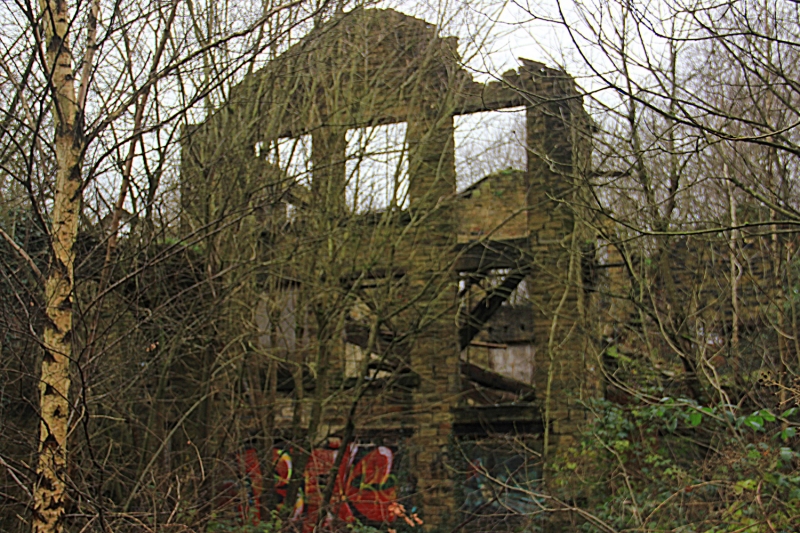
Scribbling, carding and fulling mill. c.1800 additions and alterations probably 1824. For John Shaw, clothier, of Lower West Wood. Coursed hammer dressed gritstone laid to diminishing courses; stone slate roof with roof-light removed; iron tie plates. Quoins. 3 storeys above a mill race, the ground floor taller than those above. 7 bays. All openings blocked with cement blocks or boarding at time of review.
East elevation [to mill yard]; each floor has a secondary loading door far left; original openings are the round-arched doorway [now window] with keystone and impost to bay 4 and the 2-light windows with flat-faced mullions in plain stone surrounds to first and second storeys. Wide doorway inserted to right of original has monolithic jambs and lintel; 2 altered ground floor windows to left. Far right; on the ground floor the original 2-light window has been altered and a larger opening inserted; the right-hand light of each window on each floor was partly obscured when the north range was constructed and the walling angled to create a squint.
West elevation [to dam]; added bay to north gable far left and projecting 2-bay extension with cat-slide roof to bays 2 and 3. Original range has 2- and 3-light windows to first and second floors; ground floor openings larger, with some alterations; those to right of projecting block partly obscured but including mill race opening. Projecting block, at west side has 2-light window on ground floor, and two original single light windows at first floor; walling above all one build.
Left return [facing canal] has 2-light window to ground and first floors and large blocked opening above.
North gable has tier of 3-light windows on west side and angled wall with straight join and lintel of low brick-blocked opening near ground level at left at wheel pit level. Changes in stonework indicate that north end is built on foundations of earlier building. Range is reported to retain wheel pit and turbine.
INTERIOR; not inspected.
HISTORY. Documentary evidence suggests that this is the water-powered scribbling, carding and fulling mill built in 1789 or 1801 by James Shaw who leased the fulling mill at Lower West Wood [now Titanic Mill] from the Hon. R L Savile. It was built immediately after the opening of the five-mile stretch of the Huddersfield Narrow Canal between Huddersfield and Slaithwaite and before its completion in April 1811. Records show that in 1824 it was described as 'Upper scribbling mill' when it was leased by John, Jonathan and Eli Shaw of Golcar. In this year the west side was rebuilt and the outshot building added and other modifications to the building were probably made as possibly more machines for the preparation of yarn and spinning were introduced. The water-wheel was replaced by an 85hp. Gunther & Son water turbine in 1920.
NOTE: Fire insurance plaque in centre above first floor windows.
Listing NGR: SE0949014594
External links are from the relevant listing authority and, where applicable, Wikidata. Wikidata IDs may be related buildings as well as this specific building. If you want to add or update a link, you will need to do so by editing the Wikidata entry.


Other nearby listed buildings
