Approximate Location Map
Large Map »
Latitude: 53.3864 / 53°23'11"N
Longitude: -3.0275 / 3°1'38"W
OS Eastings: 331760
OS Northings: 388220
OS Grid: SJ317882
Mapcode National: GBR 7Y98.CS
Mapcode Global: WH87D.G4LR
Plus Code: 9C5R9XPF+H2
Entry Name: Beechcroft
Listing Date: 28 March 1974
Last Amended: 10 August 1992
Grade: II
Source: Historic England
Source ID: 1218097
English Heritage Legacy ID: 389229
ID on this website: 101218097
Location: Wirral, Merseyside, CH41
County: Wirral
Electoral Ward/Division: Birkenhead and Tranmere
Parish: Non Civil Parish
Built-Up Area: Birkenhead
Traditional County: Cheshire
Lieutenancy Area (Ceremonial County): Merseyside
Church of England Parish: Tranmere St Catherine
Church of England Diocese: Chester
This list entry was subject to a Minor Amendment on 27/06/2014
SJ3188
789-1/11/92
BIRKENHEAD,
WHETSTONE LANE,
No. 67 (Beechcroft)
(Formerly listed as Former Birkenhead Chamber of Commerce, HOLLYBANK ROAD (South West side).
Previously listed as Birkenhead School of Commerce, HOLLYBANK ROAD (South side))
28/03/74
GV II
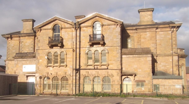
Originally a pair of houses, later used at different times as Chamber of Commerce, offices, and Islamic cultural centre and mosque. c1850. Possibly by Walter Scott. Coursed and squared stone with Welsh slate roof. Italianate style, 2 storeys, symmetrically planned. Elevation to Hollybank Road has advanced outer pedimented gables with squared bays to ground floor each with 3-round arched lights and fretted parapet over cornice. Triple round-arched windows to first floor. Central 2 window range with full-height round arched windows to ground floor, and 2-light casements above with stone balconies. Entrance porches project each side. Single-storeyed porch with fretted parapet over cornice and round arched doorways. Elevation to Whetstone Lane of 4 bays, with paired central pedimented gables each with triple round headed windows to ground and first floor. Vermiculated voussoirs and keystones to ground floor windows, stressed architraves to first floor. Single round-arched window on each gable apex with cast-iron balcony carried on stone brackets. Flanking blocks face SE and NW, with outer pedimented gables and canted bay windows to ground floor. Axial stacks with stressed quoins. The building forms part of the Clifton Park estate, laid out by Walter Scott during the 1840s.
Listing NGR: SJ3176088220
External links are from the relevant listing authority and, where applicable, Wikidata. Wikidata IDs may be related buildings as well as this specific building. If you want to add or update a link, you will need to do so by editing the Wikidata entry.


Other nearby listed buildings
