Approximate Location Map
Large Map »
Latitude: 53.37 / 53°22'11"N
Longitude: -2.9989 / 2°59'55"W
OS Eastings: 333635
OS Northings: 386366
OS Grid: SJ336863
Mapcode National: GBR 7YHG.KP
Mapcode Global: WH87D.XK4C
Plus Code: 9C5V9292+XF
Entry Name: Numbers 20 and 21 with Gatepiers to Number 21
Listing Date: 13 March 1973
Last Amended: 10 August 1992
Grade: II
Source: Historic England
Source ID: 1218814
English Heritage Legacy ID: 389322
ID on this website: 101218814
Location: Rock Park, Wirral, Merseyside, CH42
County: Wirral
Electoral Ward/Division: Rock Ferry
Parish: Non Civil Parish
Built-Up Area: Birkenhead
Traditional County: Cheshire
Lieutenancy Area (Ceremonial County): Merseyside
Church of England Parish: Rock Ferry St Peter
Church of England Diocese: Chester
Tagged with: Building
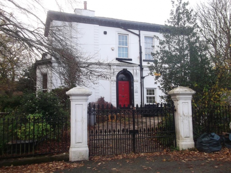
BIRKENHEAD
SJ3386 ROCK PARK, Rock Ferry
789-1/12/262 (West side)
13/03/73 Nos.20 AND 21
with gatepiers to No.21
(Formerly Listed as:
ROCK PARK
(South side)
Nos.20 AND 29)
GV II
Pair of houses. c1836. Stucco rusticated to ground floor with
Welsh slate roof. Neo-classical style, 2 storeys,
symmetrically-designed, each house a 2-window range
double-pile plan with side entrance. Slightly advanced outer
bays with canted bay window to ground floor and 12-pane sash
above in moulded architrave. Central bays have tripartite sash
windows to ground floor, and 12-pane sash window above in
moulded architrave with panelled apron and double string
course. Angle quoins, eaves cornice. Return elevations have
central round arched doorway with entablature carried on
paired console brackets. All windows in No.21 have been
lowered, and mouldings and rustication removed; it is included
for group value. No.20 has square gate piers with stepped
pyramidal cap and cast iron gates with acanthus motif. The
houses form part of the original development of Rock Park,
laid out in 1836 by Jonathan Bennison.
(The Buildings of England: Pevsner N and Hubbard E: Cheshire:
Harmondsworth: 1971-).
Listing NGR: SJ3363586366
External links are from the relevant listing authority and, where applicable, Wikidata. Wikidata IDs may be related buildings as well as this specific building. If you want to add or update a link, you will need to do so by editing the Wikidata entry.


Other nearby listed buildings
