Approximate Location Map
Large Map »
Latitude: 53.7355 / 53°44'7"N
Longitude: -2.9756 / 2°58'32"W
OS Eastings: 335739
OS Northings: 427009
OS Grid: SD357270
Mapcode National: GBR 7TN7.LN
Mapcode Global: WH85P.8C8N
Plus Code: 9C5VP2PF+5P
Entry Name: Seafield
Listing Date: 15 February 1993
Grade: II
Source: Historic England
Source ID: 1219282
English Heritage Legacy ID: 385307
ID on this website: 101219282
Location: Fylde, Lancashire, FY8
County: Lancashire
District: Fylde
Electoral Ward/Division: Clifton
Parish: Non Civil Parish
Built-Up Area: Lytham St Anne's
Traditional County: Lancashire
Lieutenancy Area (Ceremonial County): Lancashire
Church of England Parish: Lytham St Cuthbert
Church of England Diocese: Blackburn
Tagged with: Building
LYTHAM ST ANNES
SD35NE SEAFIELD ROAD, Lytham
621-1/3/84 (East side)
No.23
Seafield
II
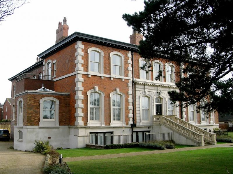
Villa, now flats. C.1860. Red brick in Flemish bond with
sandstone dressings and hipped slate roof. Double-depth plan
with back extension. Italianate style. Two storeys over
basements, 2:3:2 windows, symmetrical, the centre slightly set
back; plinth, quoined corner pilasters, sillbands to both
floors, bracketed eaves. The ground floor of the centre has a
double flight of steps (modernised) up to a segmental-headed
doorway flanked by tall segmental-headed windows, all with
shouldered architraves and keystones and set in a channelled
ashlar surround with pulvinated frieze and modillioned cornice
over the whole. All the other windows are segmental-headed
with shouldered architraves, those at ground floor with
altered glazing and those above all 4-pane sashes. Attached at
each end is a set-back single-storey one-bay wing in similar
style. INTERIOR: entrance hall containing open-well staircase
with cast-iron balusters; otherwise not inspected.
Listing NGR: SD3573927009
External links are from the relevant listing authority and, where applicable, Wikidata. Wikidata IDs may be related buildings as well as this specific building. If you want to add or update a link, you will need to do so by editing the Wikidata entry.


Other nearby listed buildings
