Approximate Location Map
Large Map »
Latitude: 53.7381 / 53°44'17"N
Longitude: -2.9566 / 2°57'23"W
OS Eastings: 336995
OS Northings: 427278
OS Grid: SD369272
Mapcode National: GBR 7TS6.PR
Mapcode Global: WH85P.K99N
Plus Code: 9C5VP2QV+68
Entry Name: 2, Station Road
Listing Date: 15 February 1993
Grade: II
Source: Historic England
Source ID: 1219380
English Heritage Legacy ID: 385318
ID on this website: 101219380
Location: Lytham, Fylde, Lancashire, FY8
County: Lancashire
District: Fylde
Electoral Ward/Division: Clifton
Parish: Non Civil Parish
Built-Up Area: Lytham St Anne's
Traditional County: Lancashire
Lieutenancy Area (Ceremonial County): Lancashire
Church of England Parish: Lytham St John the Divine
Church of England Diocese: Blackburn
Tagged with: Building
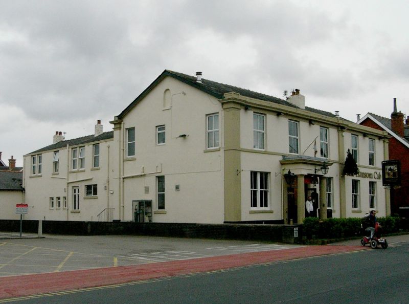
LYTHAM ST ANNES
SD3627SE STATION ROAD, Lytham
621-1/6/87 (East side)
No.2
GV II
Formerly known as: No.2 The Station Hotel STATION ROAD Lytham.
Hotel, now public house. Mid C19, altered. Painted stucco,
probably on brick, with sandstone dressings and hipped slate
roof. Rectangular plan with back extensions. Simple classical
style. Two storeys over cellars, 3:2 bays, with pilasters at
the corners and between the 3rd and 4th bays, and a plain
frieze and moulded cornice. The 3-bay portion is symmetrical,
with a central entrance protected by a porch with 2 fluted
Doric columns and entablature, flanked by coupled 4-pane
sashed windows. The 2-bay portion to the right has 4-pane
sashes at ground floor. All the windows at 1st floor have
altered glazing. One cut-down chimney on the front slope of
the roof, and 2 inserted metal flues. Sides walls with various
altered windows. INTERIOR remodelled. HISTORY: associated with
railway terminus station built on site to north in 1846, but
recently demolished.
Listing NGR: SD3699527278
External links are from the relevant listing authority and, where applicable, Wikidata. Wikidata IDs may be related buildings as well as this specific building. If you want to add or update a link, you will need to do so by editing the Wikidata entry.


Other nearby listed buildings
