Approximate Location Map
Large Map »
Latitude: 52.6377 / 52°38'15"N
Longitude: 1.2926 / 1°17'33"E
OS Eastings: 622881
OS Northings: 309534
OS Grid: TG228095
Mapcode National: GBR W8V.N7
Mapcode Global: WHMTF.TYPQ
Plus Code: 9F43J7QV+32
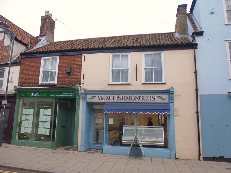
Entry Name: 27-29, St Augustine's Street
Listing Date: 8 April 1986
Grade: II
Source: Historic England
Source ID: 1220544
English Heritage Legacy ID: 229484
ID on this website: 101220544
Location: Coslany, Norwich, Norfolk, NR3
County: Norfolk
District: Norwich
Electoral Ward/Division: Mancroft
Parish: Non Civil Parish
Built-Up Area: Norwich
Traditional County: Norfolk
Lieutenancy Area (Ceremonial County): Norfolk
Church of England Parish: New Catton St Luke with St Augustine
Church of England Diocese: Norwich
Tagged with: Building
TG 2209 NE ST. AUGUSTINE'S STREET
(north-east side)
7/712
- Nos. 27 to 29 (odd)
GV II
Former use unknown, now shops. Of refaced in the late C19 timber-framed,
clad at first floor level in red brick, No. 27 being rendered. Pantile roof
with stack to south-east gable. 2 storeys. 3 bays. C19 shop fronts and sash
windows above. Ground and first floor ceilings with chamfered tie beams.
Stack stairs away from street. C18 rear extensions.
Listing NGR: TG2288109534
External links are from the relevant listing authority and, where applicable, Wikidata. Wikidata IDs may be related buildings as well as this specific building. If you want to add or update a link, you will need to do so by editing the Wikidata entry.


Other nearby listed buildings
