Approximate Location Map
Large Map »
Latitude: 53.6514 / 53°39'4"N
Longitude: -1.7341 / 1°44'2"W
OS Eastings: 417675
OS Northings: 417238
OS Grid: SE176172
Mapcode National: GBR JVB6.CT
Mapcode Global: WHCB2.BHH5
Plus Code: 9C5WM728+G9
Entry Name: 1-7, School Lane
Listing Date: 29 September 1978
Grade: II
Source: Historic England
Source ID: 1221597
English Heritage Legacy ID: 412952
ID on this website: 101221597
Location: Waterloo, Kirklees, West Yorkshire, HD5
County: Kirklees
Electoral Ward/Division: Dalton
Parish: Non Civil Parish
Built-Up Area: Huddersfield
Traditional County: Yorkshire
Lieutenancy Area (Ceremonial County): West Yorkshire
Church of England Parish: Kirkheaton St John the Baptist
Church of England Diocese: Leeds
Tagged with: Building
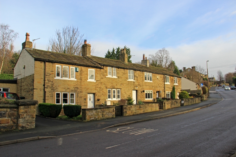
SCHOOL LANE
1.
5113
(North Side)
Kirkheaton
Nos 1 to 7 (odd)
SE 1717 29/1188
II
2.
C18 or C19. Hammer dressed stone. Pitched stone slate roof. 2 storeys.
1st floor has two 3-light and one 2-light stone mullioned windows and 5 casements.
Ground floor has two 3-light stone mullioned windows and 2 casements.
Listing NGR: SE1767517238
External links are from the relevant listing authority and, where applicable, Wikidata. Wikidata IDs may be related buildings as well as this specific building. If you want to add or update a link, you will need to do so by editing the Wikidata entry.


Other nearby listed buildings
