Approximate Location Map
Large Map »
Latitude: 51.5213 / 51°31'16"N
Longitude: -0.16 / 0°9'35"W
OS Eastings: 527755
OS Northings: 181872
OS Grid: TQ277818
Mapcode National: GBR 88.8T
Mapcode Global: VHGQZ.51S2
Plus Code: 9C3XGRCR+G2
Entry Name: Westminster Council House
Listing Date: 16 January 1981
Grade: II
Source: Historic England
Source ID: 1222688
English Heritage Legacy ID: 418104
ID on this website: 101222688
Location: Lisson Grove, Westminster, London, NW1
County: London
District: City of Westminster
Electoral Ward/Division: Bryanston and Dorset Square
Parish: Non Civil Parish
Built-Up Area: City of Westminster
Traditional County: Middlesex
Lieutenancy Area (Ceremonial County): Greater London
Church of England Parish: St Mary Bryanston Square
Church of England Diocese: London
Tagged with: City hall Seat of local government
TQ 2781 NE CITY OF WESTMINSTER MARYLEBONE ROAD, NW1
43/5
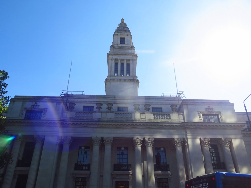
Westminster Council House
16.1.81.
G.V. II
Council house, formerly Marylebone Town Hall. 1914-20 by Sir Edwin Cooper.
Portland stone, flat terrace roof. Edwardian Graeco-Roman classicism
relying on mass and volume for broad fronted composition with elaboration
reserved for Wren inspired central tower. Rusticated semi basement, 2 main
storeys and attic storey. 13 bays wide, the 7 central bays advanced as
centrepiece. Central tetrastyle portico in antis with coupled giant
Corinthian columns, approached by flight of steps flanked by lions; the
portico, flanked by slightly advanced one-bay pavilions with giant
Corinthian columns in antis. The attic is set back and taller above
portico, fronted by a balustraded parapet, with pairs of vases surmounting
dies, rising over the bracketed cornice of the entablature. The attic
windows of the centrepiece have armorial surrounds. Plain windows to
wings. Return elevations of 8 bays, the terminal ones treated as similar
pavilions to those flanking portico. The tall square tower is set back
with Corinthian colonnade above plain base with pedimented and recessed
stages above rising as stepped spire crowned by urn finial. Stone area
balustrade surrounds site. Interior not inspected. Town Hall has bridge
link to Cooper's later Library to west.
Listing NGR: TQ2775581872
External links are from the relevant listing authority and, where applicable, Wikidata. Wikidata IDs may be related buildings as well as this specific building. If you want to add or update a link, you will need to do so by editing the Wikidata entry.


Other nearby listed buildings
