Approximate Location Map
Large Map »
Latitude: 51.7469 / 51°44'48"N
Longitude: -2.2169 / 2°13'1"W
OS Eastings: 385118
OS Northings: 205376
OS Grid: SO851053
Mapcode National: GBR 1MK.JB4
Mapcode Global: VH94Y.JCB5
Plus Code: 9C3VPQWM+Q6
Entry Name: Ye Old Painswick Inn
Listing Date: 18 March 1994
Grade: II
Source: Historic England
Source ID: 1223601
English Heritage Legacy ID: 419352
Also known as: The Painswick Inn, Stroud
The Painswick Inn Project
Shire Training Workshops
OPENhouse
Five Valleys Foyer
ID on this website: 101223601
Location: Stroud, Gloucestershire, GL5
County: Gloucestershire
District: Stroud
Civil Parish: Stroud
Built-Up Area: Stroud
Traditional County: Gloucestershire
Lieutenancy Area (Ceremonial County): Gloucestershire
Church of England Parish: Stroud St Laurence
Church of England Diocese: Gloucester
Tagged with: Inn Pub Office building
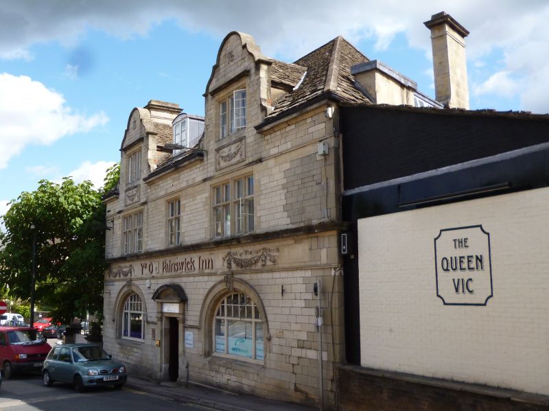
1. STROUD GLOUCESTER STREET
SO 85 05
5/10008 Ye Old Painswick Inn
II
Public house. 1890, by W.H.C. Fisher. Built of red brick with principal elevations faced in
squared and coursed limestone; stone slate roofs; ashlar stacks with moulded cornicing to main
range. Rectangular plan with main entrance flanked by 2 bars; stable yard to left (north). Free
Style. 2 storeys and attic; 3-window first-floor range to front. Segmental-pedimented doorcase
in Early Georgian style, flanked by transomed windows with stilted keyed and segmental arches;
keys touch string course, which forms lower part of a broad horizontal band which includes
lettering flanked by swags and is surmounted by heavy cornice; 4-light flank 2-light
stone-mullioned and transomed windows to first floor, which sit on cornice and are surmounted
by a continuous drip course which forms the lower part of a band at eaves level; swagged aprons
beneath 3-light stone-mullioned attic windows with drip moulds, which are set in full-height
dormers with Dutch gables. Horizontal courses are continued to articulate return elevations, with
similar fenestration. Interior includes original joinery and plaster cornicing. Subsidiary Features:
stable yard to left (north) is bounded on east and north-east sides by range of similar materials;
3-bay cartshed with cast-iron piers and Welsh slate roof is connected on the north to a range
enclosing north-east side of yard, of one storey and attic with stone lintels over 3-light casements,
including gabled half-dormers, and opening with sliding door; gable end facing Slad Road
includes oculus set beneath Dutch gable. Fisher was a local architect, who had worked with J.P.
Seddon on the School of Art and Science in Lansdowne (qv), also of 1890. A fine and
well-preserved example of late C19 public house architecture in a favoured style, complete with
its stable yard.
Listing NGR: SO8511805376
External links are from the relevant listing authority and, where applicable, Wikidata. Wikidata IDs may be related buildings as well as this specific building. If you want to add or update a link, you will need to do so by editing the Wikidata entry.


Other nearby listed buildings
