Approximate Location Map
Large Map »
Latitude: 51.525 / 51°31'29"N
Longitude: -0.2152 / 0°12'54"W
OS Eastings: 523913
OS Northings: 182184
OS Grid: TQ239821
Mapcode National: GBR BD.QD8
Mapcode Global: VHGQR.7X2T
Plus Code: 9C3XGQFM+XW
Entry Name: Kensal House
Listing Date: 19 March 1981
Grade: II*
Source: Historic England
Source ID: 1225244
English Heritage Legacy ID: 421529
ID on this website: 101225244
Location: Kensal Town, Kensington and Chelsea, London, W10
County: London
District: Kensington and Chelsea
Electoral Ward/Division: Dalgarno
Parish: Non Civil Parish
Built-Up Area: Kensington and Chelsea
Traditional County: Middlesex
Lieutenancy Area (Ceremonial County): Greater London
Church of England Parish: St Thomas Kensal Road
Church of England Diocese: London
Tagged with: Apartment building
This list entry was subject to a Minor Amendment on 01/06/2018
TQ 2382 SE
5/3
LADBROKE GROVE W10
Kensal House
Nos 1 to 68 (consec)
19.3.81
GV II*
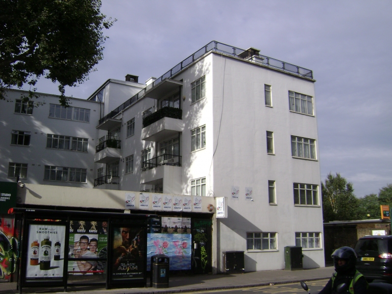
Linked blocks of flats. 1936-8. Architects: F Maxwell Fry and Grey Wornum. Reinforced concrete. Two neat parallel blocks, the west one L-shaped with the larger (north-south) arm gently curved. Housing plus a Day Nursery, the latter in a crescent-shaped building facing onto a sunken playground immediately west of the west block. Together they form 2 courtyards opening southwards towards the Great Western Railway line. Stucco. Flat-roofed with parapets. Uniform metal-framed casements. Glazed wooden doors with 4 plain transoms each, and cantilevered reinforced concrete slab hoods. 5 storeys, 6 where ground falls away to south; small attic superstructures in middle of each block.
East block has 12 bays (symmetrically arranged: 4-light casements in end bays, 5-light casements in 2 middle bays, otherwise 3-light casements). Cantilevered reinforced concrete slab porch at north end, and plain concrete balcony with steps down at south end; bridge linking it to a similar balcony along west block.
The basement of the east block contained community rooms including a hall with a stage at the south end (still in situ), snack bar and activity rooms.
West block has 6 bays in short arm (of which 2 are balcony bays), and 22 bays in long arm (also symmetrically arranged). Short arm has flat carriage arch to allow access to car park in north half of internal courtyard: the southern half is a garden.
West elevations of both blocks have 2 types of balcony, alternating with 2 bays of regular fenestration. One type is cantilevered reinforced concrete with flat hoods an plain concrete partitions. Other type is smaller, in antis, with perforated concrete balustrades: the latter type flank staircase bays.
Listing NGR: TQ2391382184
External links are from the relevant listing authority and, where applicable, Wikidata. Wikidata IDs may be related buildings as well as this specific building. If you want to add or update a link, you will need to do so by editing the Wikidata entry.


Other nearby listed buildings
