Approximate Location Map
Large Map »
Latitude: 53.0193 / 53°1'9"N
Longitude: -2.5828 / 2°34'57"W
OS Eastings: 361003
OS Northings: 347049
OS Grid: SJ610470
Mapcode National: GBR 7Q.FWNW
Mapcode Global: WH9BH.9CCN
Plus Code: 9C5V2C98+PV
Entry Name: Aston House Farmhouse
Listing Date: 12 January 1967
Grade: II
Source: Historic England
Source ID: 1225739
English Heritage Legacy ID: 422248
ID on this website: 101225739
Location: Aston, Cheshire East, Cheshire, CW5
County: Cheshire East
Civil Parish: Newhall
Built-Up Area: Aston
Traditional County: Cheshire
Lieutenancy Area (Ceremonial County): Cheshire
Church of England Parish: Wrenbury St Margaret
Church of England Diocese: Chester
Tagged with: Farmhouse
NEWHALL C.P. WRENBURY ROAD
SJ 64 NW
Aston House Farmhouse
3/71
12.1.67
II
GV
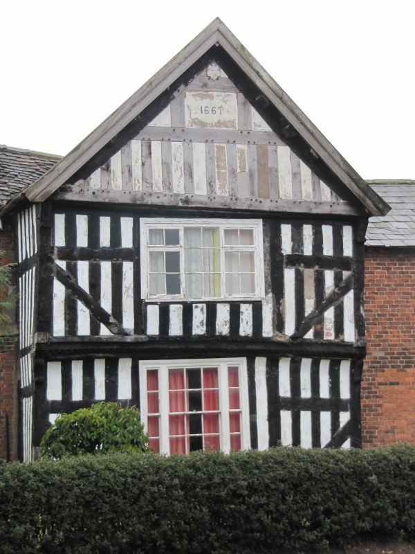
Farmhouse. Dated 1662 with C19 extensions and alterations. Timber
framed with a plain tile roof and random frond brick with a slate roof.
The entrance front has at left a gabled projecting wing dated to the
gable with close studding,middle rail and passing tension braces. To
the centre is a later C19 triple-light window of 3 x 4 panes with
lateral windows of 1 x 4 panes. Jettied first floor with decorative
brackets supporting the keel-moulded bressumer. The first floor is
close studded with a middle rail and has tension bracing. Three-light
C19 or C20 casement window to the centre. To either side are Moulded
brackets supporting the jettied gable which has a moulded bressumer.
Close studding to the gable. The date is painted on in C20 script.
Three pairs of purlins and one ridge beam. To the right of this gable,
and slightly recessed are 3 bays of C19 brick with ground and
first-floor windows all of 4 x 4 sash panes with stone cills and
flat-arched heads. The left hand side has, to right of centre, a
massive chimney stack with sandstone lower body with chamfered top and
red brick above this with offsets. To right is some close-studding at
first floor level, the rest of the brick walling being painted in
imitation of timber framing.
Listing NGR: SJ6100347049
External links are from the relevant listing authority and, where applicable, Wikidata. Wikidata IDs may be related buildings as well as this specific building. If you want to add or update a link, you will need to do so by editing the Wikidata entry.


Other nearby listed buildings
