Approximate Location Map
Large Map »
Latitude: 50.7664 / 50°45'58"N
Longitude: -3.4452 / 3°26'42"W
OS Eastings: 298176
OS Northings: 97304
OS Grid: SX981973
Mapcode National: GBR P2.Y53V
Mapcode Global: FRA 37N2.5LW
Plus Code: 9C2RQH83+GW
Entry Name: Tomb Chest 15 Metres North of Parish Church and Immediately West of Cross
Listing Date: 20 May 1985
Grade: II
Source: Historic England
Source ID: 1225916
English Heritage Legacy ID: 422931
ID on this website: 101225916
Location: St John the Baptist Church, Broadclyst, East Devon, EX5
County: Devon
District: East Devon
Civil Parish: Broad Clyst
Built-Up Area: Broadclyst
Traditional County: Devon
Lieutenancy Area (Ceremonial County): Devon
Church of England Parish: Broadclyst St John the Baptist
Church of England Diocese: Exeter
Tagged with: Tomb
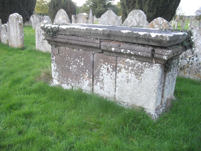
SX 99 NE BROADCLYST BROADCLYST
9/66 Tomb Chest 15 metres north of
- Parish Church and immediately west
of cross
GV II
Tomb Chest. C18 or late-C17. Stone, moulded top and panelled sides. No
inscription visible.
Listing NGR: SX9817497288
External links are from the relevant listing authority and, where applicable, Wikidata. Wikidata IDs may be related buildings as well as this specific building. If you want to add or update a link, you will need to do so by editing the Wikidata entry.


Other nearby listed buildings
