Approximate Location Map
Large Map »
Latitude: 52.129 / 52°7'44"N
Longitude: 0.4278 / 0°25'39"E
OS Eastings: 566276
OS Northings: 250638
OS Grid: TL662506
Mapcode National: GBR NCB.DZ5
Mapcode Global: VHJH3.CRH7
Plus Code: 9F424CHH+J4
Entry Name: Low Farmhouse
Listing Date: 20 May 1974
Grade: II
Source: Historic England
Source ID: 1227222
English Heritage Legacy ID: 424898
ID on this website: 101227222
Location: Temple End, West Suffolk, CB9
County: Suffolk
District: West Suffolk
Civil Parish: Little Thurlow
Traditional County: Suffolk
Lieutenancy Area (Ceremonial County): Suffolk
Church of England Parish: Little Thurlow St Peter
Church of England Diocese: St.Edmundsbury and Ipswich
Tagged with: Farmhouse
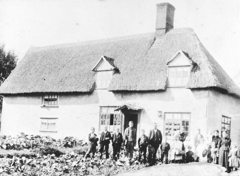
1. LITTLE THURLOW LITTLE THURLOW
2006
Temple End
Low Farmhouse
TL 6751 22/375
II
2.
A C17 timber-framed and plastered house. Partly 1 storey and attics and partly
2 storeys. The windows are casements with glazing bars. (C20). Roof thatched,
with 2 gabled dormers, hipped at the east end.
Listing NGR: TL6627650638
External links are from the relevant listing authority and, where applicable, Wikidata. Wikidata IDs may be related buildings as well as this specific building. If you want to add or update a link, you will need to do so by editing the Wikidata entry.


Other nearby listed buildings
