Approximate Location Map
Large Map »
Latitude: 50.7319 / 50°43'54"N
Longitude: -2.7579 / 2°45'28"W
OS Eastings: 346609
OS Northings: 92746
OS Grid: SY466927
Mapcode National: GBR PP.0C5F
Mapcode Global: FRA 5734.PDZ
Plus Code: 9C2VP6JR+PV
Entry Name: 43, South Street
Listing Date: 19 September 1975
Grade: II
Source: Historic England
Source ID: 1227858
English Heritage Legacy ID: 402343
ID on this website: 101227858
Location: New Zealand, Dorset, DT6
County: Dorset
Civil Parish: Bridport
Built-Up Area: Bridport
Traditional County: Dorset
Lieutenancy Area (Ceremonial County): Dorset
Church of England Parish: Bridport St Mary
Church of England Diocese: Salisbury
Tagged with: Building
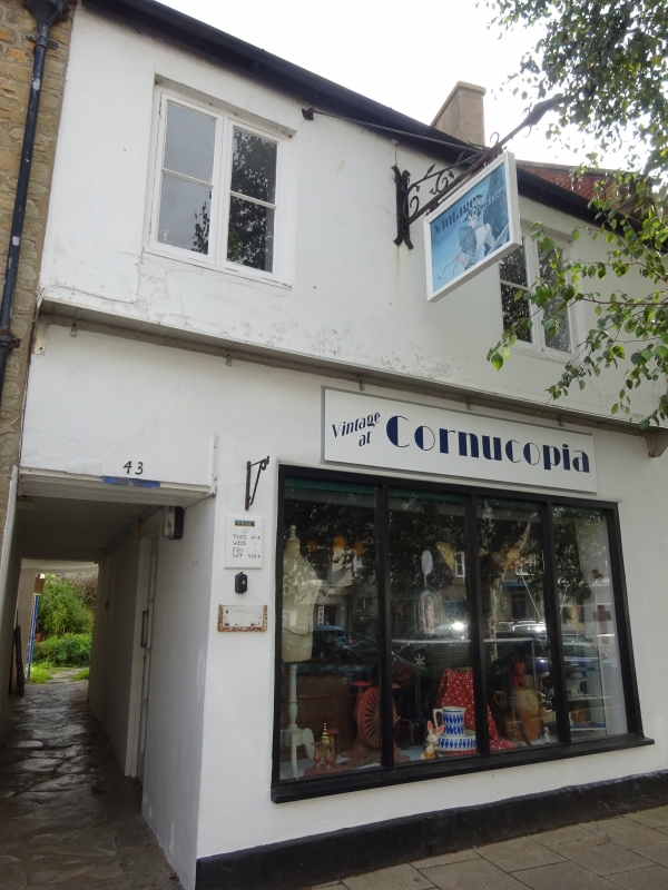
1 .
5l91 SOUTH STREET STREET )
(East Side)
No 43
SY 4692 1/431
II nv
2.
Probably C18. Rendered. Pitched slate roof. 2 storeys. 2 casements on
lst floor. Late C19 tripartite sash and modern door on ground floor. 6-panel
door to covered passageway at left hand. 1 storey extension to rear with
lean-to pantile roof.
Nos 37 to 43 (odd) and 43A and 43B form a group.
Listing NGR: SY4660992746
External links are from the relevant listing authority and, where applicable, Wikidata. Wikidata IDs may be related buildings as well as this specific building. If you want to add or update a link, you will need to do so by editing the Wikidata entry.


Other nearby listed buildings
