Approximate Location Map
Large Map »
Latitude: 51.2628 / 51°15'45"N
Longitude: -1.087 / 1°5'13"W
OS Eastings: 463798
OS Northings: 151906
OS Grid: SU637519
Mapcode National: GBR B6H.N11
Mapcode Global: VHD08.3JPB
Plus Code: 9C3W7W77+45
Entry Name: Town Hall, with Attached Drinking Fountain
Listing Date: 6 November 1984
Grade: II
Source: Historic England
Source ID: 1230876
English Heritage Legacy ID: 137930
ID on this website: 101230876
Location: Basingstoke, Basingstoke and Deane, Hampshire, RG21
County: Hampshire
District: Basingstoke and Deane
Electoral Ward/Division: Eastrop
Parish: Non Civil Parish
Built-Up Area: Basingstoke
Traditional County: Hampshire
Lieutenancy Area (Ceremonial County): Hampshire
Church of England Parish: Basingstoke
Church of England Diocese: Winchester
Tagged with: City hall Museum Seat of local government Independent museum
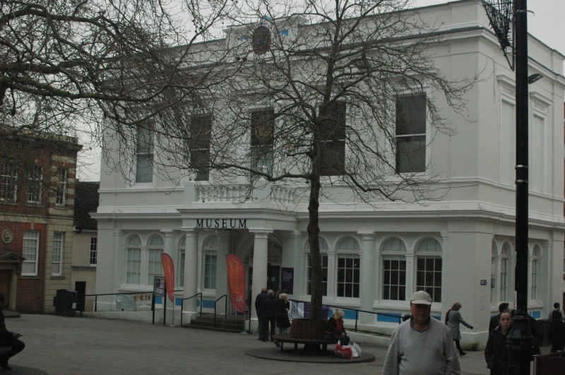
SU 63 6451 (part) BASINGSTOKE MARKET PLACE
3/29
Town Hall, with
attached drinking
fountain.
- II
1835. A symmetrical facade of classical form; 2 storeys, 5 1st floor windows.
Stucco walling: the parapet has a moulded coping and a stepped panel above a fully
moulded cornice and plain frieze, the centre (above the cornice) being raised to
accommodate a decorative cartouche between pilasters. At each side there are
pilasters, passing through the 1st floor stage which is marked by a moulded cill
band and plinth, resting on a cornice and frieze, a plain ground floor stage is
divided between aide and central entrance by ½ columns separating coupled arched
windows above panels; the arched doorway is part of a Tuscan porch (of 2 column
2 pilasters) with a balustered parapet. The upper windows have an architrave
below a cornice and pulvinated frieze Victorian sashes to 1st floor, casements on
ground floor. The classical form continues for 2 bays at each end (facing Church
Street and Wote Street), extending a further 2 bays in red brickwork. C19 drinking
fountain to rear, (temporarily removed at time of re-survey).
Listing NGR: SU6223851421
External links are from the relevant listing authority and, where applicable, Wikidata. Wikidata IDs may be related buildings as well as this specific building. If you want to add or update a link, you will need to do so by editing the Wikidata entry.


Other nearby listed buildings
