Approximate Location Map
Large Map »
Latitude: 53.6444 / 53°38'39"N
Longitude: -1.7801 / 1°46'48"W
OS Eastings: 414635
OS Northings: 416451
OS Grid: SE146164
Mapcode National: GBR JV09.DB
Mapcode Global: WHCB1.MNKJ
Plus Code: 9C5WJ6V9+PX
Entry Name: 28, Queen Street
Listing Date: 29 September 1978
Grade: II
Source: Historic England
Source ID: 1231222
English Heritage Legacy ID: 406301
ID on this website: 101231222
Location: Huddersfield, Kirklees, West Yorkshire, HD1
County: Kirklees
Electoral Ward/Division: Newsome
Parish: Non Civil Parish
Built-Up Area: Huddersfield
Traditional County: Yorkshire
Lieutenancy Area (Ceremonial County): West Yorkshire
Church of England Parish: Huddersfield St Peter
Church of England Diocese: Leeds
Tagged with: Building
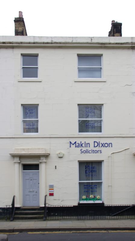
QUEEN STREET
1.
5113
(East Side)
No 28
SE 1416 SE 4/1115
II GV
2.
Early C19. Painted ashlar. 3 storeys. Moulded eaves cornice and blocking
course. 2 ranges of sashes, ground floor window tripartite. Door with 6 moulded
panels in stone surround with Tuscan 3/4 columns and entablature. 3 steps
with plain cast iron railings.
Listing NGR: SE1463416463
External links are from the relevant listing authority and, where applicable, Wikidata. Wikidata IDs may be related buildings as well as this specific building. If you want to add or update a link, you will need to do so by editing the Wikidata entry.


Other nearby listed buildings
