Approximate Location Map
Large Map »
Latitude: 52.9572 / 52°57'25"N
Longitude: -1.8409 / 1°50'27"W
OS Eastings: 410787
OS Northings: 339988
OS Grid: SK107399
Mapcode National: GBR 380.PD5
Mapcode Global: WHCF9.PXLV
Plus Code: 9C4WX545+VM
Entry Name: Milepost at Ngr SK 1074 3992
Listing Date: 30 May 1985
Grade: II
Source: Historic England
Source ID: 1231908
English Heritage Legacy ID: 406082
ID on this website: 101231908
Location: Rocester, East Staffordshire, ST14
County: Staffordshire
District: East Staffordshire
Civil Parish: Rocester
Built-Up Area: Rocester
Traditional County: Staffordshire
Lieutenancy Area (Ceremonial County): Staffordshire
Church of England Parish: Rocester St Michael
Church of England Diocese: Lichfield
Tagged with: Milestone
SK 1039-1139 ROCESTER C.P. B 5030 (West side)
Ashbourne Rd
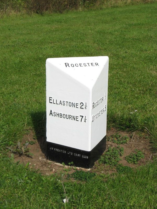
10/155 Milepost at N.G.R.
- SK 10743992
- II
Milepost. Mid to late C19. Cast iron. Triangular section
with chamfered top. Top face: "ROCESTER" Left hand face:
"ELLASTONE 2¼ / ASHBOURNE 7¼" Right hand face: "ROCESTER ½ /
UTTOXETER 5".
Listing NGR: SK1078739987
External links are from the relevant listing authority and, where applicable, Wikidata. Wikidata IDs may be related buildings as well as this specific building. If you want to add or update a link, you will need to do so by editing the Wikidata entry.


Other nearby listed buildings
