Approximate Location Map
Large Map »
Latitude: 53.2112 / 53°12'40"N
Longitude: -0.8167 / 0°49'0"W
OS Eastings: 479118
OS Northings: 368889
OS Grid: SK791688
Mapcode National: GBR CJW.QBG
Mapcode Global: WHFGX.FK92
Plus Code: 9C5X656M+F8
Entry Name: Church Farm Farmhouse and Attached Farm Buildings
Listing Date: 12 July 1985
Grade: II
Source: Historic England
Source ID: 1233709
English Heritage Legacy ID: 409291
ID on this website: 101233709
Location: Normanton on Trent, Bassetlaw, Nottinghamshire, NG23
County: Nottinghamshire
District: Bassetlaw
Civil Parish: Normanton on Trent
Built-Up Area: Normanton on Trent
Traditional County: Nottinghamshire
Lieutenancy Area (Ceremonial County): Nottinghamshire
Church of England Parish: Normanton-upon-Trent
Church of England Diocese: Southwell and Nottingham
Tagged with: Farmhouse
SK 76 NE
5/48
NORMANTON-ON-TRENT
MAIN STREET
(west side)
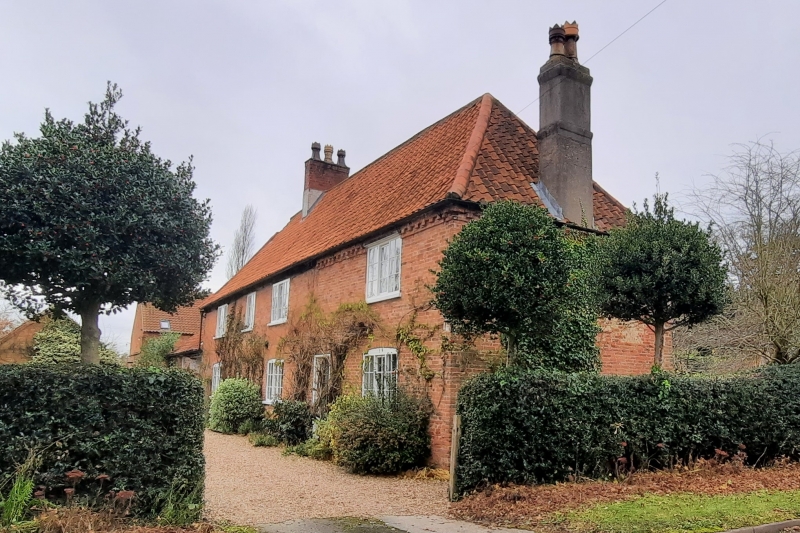
Church Farm Farmhouse and attached out-buildings
G.V.
II
House. Mid C17, refaced mid and late C18. Red brick, originally
timber framed with some remaining timbers. Hipped pantile roof
with single red brick ridge stack and single rendered stack to
the right. Dentil eaves to right 2 bays. 2 storeys, 5 bays.
Originally with a baffle entry. Having from left to right a
single tripartite glazing bar Yorkshire sash, a blocked doorway,
a single, similar sash, a part glazed door and a single similar
sash. All sashes are under segmental arches. Above from left to
right is a single tripartite glazing bar Yorkshire sash, single
smaller glazing bar Yorkshire sash and 2 similar tripartite
sashes. There is a single round tie plate. To the left is a
single storey outbuilding. Red brick, pantile roof, dentil eaves
with a large opening and to the left a single glazing bar
casement. To the rear is a storey extension. Evidence of
wall plates to front and rear, rear front is also set on a
coursed rubble plinth and has remains of 3 main posts and of 2
braces Interior contains many beams including a large chamfered
central beam, in the central room this and some other beams have
ogee stops. There is also an inglenook fireplace.
Listing NGR: SK7911868889
External links are from the relevant listing authority and, where applicable, Wikidata. Wikidata IDs may be related buildings as well as this specific building. If you want to add or update a link, you will need to do so by editing the Wikidata entry.


Other nearby listed buildings
