Approximate Location Map
Large Map »
Latitude: 51.1848 / 51°11'5"N
Longitude: 0.93 / 0°55'48"E
OS Eastings: 604864
OS Northings: 146920
OS Grid: TR048469
Mapcode National: GBR SXQ.MZ0
Mapcode Global: VHKKH.2HJ3
Plus Code: 9F325WMJ+W2
Entry Name: Wye Bridge
Listing Date: 13 October 1952
Grade: II*
Source: Historic England
Source ID: 1234208
English Heritage Legacy ID: 410052
ID on this website: 101234208
Location: Wye, Ashford, Kent, TN25
County: Kent
District: Ashford
Civil Parish: Wye with Hinxhill
Built-Up Area: Wye
Traditional County: Kent
Lieutenancy Area (Ceremonial County): Kent
Tagged with: Road bridge
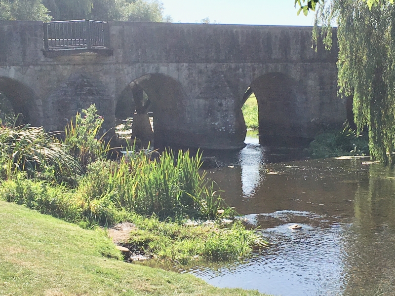
TR 0446 0456 WYE BRIDGE STREET
(west end)
8/197 Wye Bridge
13.10.52
GV II*
Bridge. 1638, repaired 1684 and altered 1881. Stone, with iron roadway.
Five round headed arches with 2 V-shaped pointed cutwaters up and down
stream, the parapet removed 1881 when the cantilevered iron roadway was
laid. Stone recording its building by the Country 1638 and repair:-
1684 now in Church of St Gregory and St Martin.
Listing NGR: TR0486446920
External links are from the relevant listing authority and, where applicable, Wikidata. Wikidata IDs may be related buildings as well as this specific building. If you want to add or update a link, you will need to do so by editing the Wikidata entry.


Other nearby listed buildings
