Approximate Location Map
Large Map »
Latitude: 51.369 / 51°22'8"N
Longitude: 0.2954 / 0°17'43"E
OS Eastings: 559879
OS Northings: 165828
OS Grid: TQ598658
Mapcode National: GBR Y5.F56
Mapcode Global: VHHP8.2VJD
Plus Code: 9F32979W+J5
Entry Name: Oliver's Farmhouse
Listing Date: 22 October 1982
Grade: II
Source: Historic England
Source ID: 1235104
English Heritage Legacy ID: 411259
ID on this website: 101235104
Location: New Ash Green, Sevenoaks, Kent, TN15
County: Kent
District: Sevenoaks
Civil Parish: Ash-cum-Ridley
Built-Up Area: Hartley (Sevenoaks)
Traditional County: Kent
Lieutenancy Area (Ceremonial County): Kent
Church of England Parish: Ash St Peter and St Paul
Church of England Diocese: Rochester
Tagged with: Farmhouse
ASH-CUM-RIDLEY BUTCHERS LANE
1.
5280
West Yoke
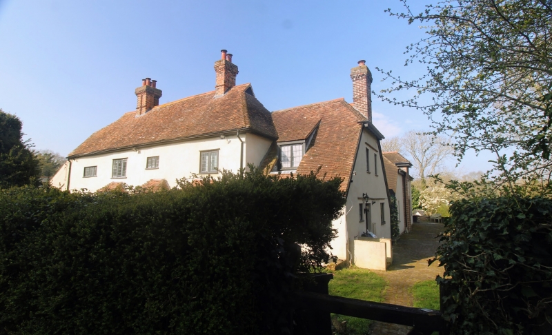
Oliver's Farmhouse
TQ 56 NE 3/3
II GV
2.
C17 or earlier timber-framed building. Two storeys timber-framed, now plastered.
Half hipped tiled roof. Four casement windows. Modern bays and porch on the
ground floor.
Listing NGR: TQ5987965828
External links are from the relevant listing authority and, where applicable, Wikidata. Wikidata IDs may be related buildings as well as this specific building. If you want to add or update a link, you will need to do so by editing the Wikidata entry.


Other nearby listed buildings
