Approximate Location Map
Large Map »
Latitude: 52.0539 / 52°3'14"N
Longitude: 1.1602 / 1°9'36"E
OS Eastings: 616762
OS Northings: 244220
OS Grid: TM167442
Mapcode National: GBR VP7.64D
Mapcode Global: VHLBT.2M6T
Plus Code: 9F433536+H3
Entry Name: 57, Fore Street
Listing Date: 20 May 1981
Last Amended: 21 March 1994
Grade: II
Source: Historic England
Source ID: 1236902
English Heritage Legacy ID: 428038
ID on this website: 101236902
Location: Ipswich, Suffolk, IP4
County: Suffolk
District: Ipswich
Electoral Ward/Division: Alexandra
Parish: Non Civil Parish
Built-Up Area: Ipswich
Traditional County: Suffolk
Lieutenancy Area (Ceremonial County): Suffolk
Church of England Parish: Ipswich St Clement with St Luke
Church of England Diocese: St.Edmundsbury and Ipswich
Tagged with: Building
The following entry:-
TM 1644 SE FORE STREET
4/505 Old warehouse behind
yard between Nos 28 and 42
- II
shall be amended to read:-
TM 1644 SE FORE STREET
(north east side)
4/10002 No 57
GV II
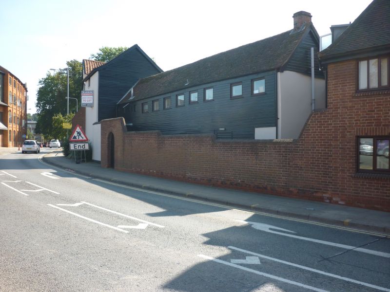
Warehouse, now offices. C15/C16 timber-frame, dismantled 1982 and re-erected 1989-90.
Timber-frame with brick and stucco and C20 tile and slate roof L-plan. 2 storeys; 3-window
range with 6 windows to ground floor. Entrance to rear. Interior retains 6 bays of framing of
longer wing and 4 bays of the shorter. First floor and roof mainly complete and wall posts partly
survive to ground floor. Close studding with tension braces and ties with curved braces. Single
tier of purlins with curved windbraces; collars and coupled rafters. Dismantled in 1982, the
timber frame moved from the other side of Fore Street was re-erected on this site in 1989-91.
A very rare survival of an Ipswich warehouse.
------------------------------------
1. FORE STREET
1260
Old warehouse
behind yard between
Nos 28 and 42
TM 1644 SE 4/505
II
2.
C15/16. Timber framed warehouse on L-shaped plan. Outside walls hardly visible
and roof covered in corrugated iron. Much of the original fabric, particularly
from the first floor up still survives and most of the roof structure. Heavy
roof construction with angled wood braces to purlins and angled braces to tie
beam. Some of the timber framed walling survives and two original windows.
Listing NGR: TM1676244220
External links are from the relevant listing authority and, where applicable, Wikidata. Wikidata IDs may be related buildings as well as this specific building. If you want to add or update a link, you will need to do so by editing the Wikidata entry.


Other nearby listed buildings
