Approximate Location Map
Large Map »
Latitude: 51.5179 / 51°31'4"N
Longitude: -0.1685 / 0°10'6"W
OS Eastings: 527171
OS Northings: 181471
OS Grid: TQ271814
Mapcode National: GBR 6B.B2
Mapcode Global: VHGQZ.137R
Plus Code: 9C3XGR9J+4H
Entry Name: 6-36, Sussex Gardens W2
Listing Date: 5 February 1970
Grade: II
Source: Historic England
Source ID: 1237426
English Heritage Legacy ID: 428683
ID on this website: 101237426
Location: Paddington, Westminster, London, W2
County: London
District: City of Westminster
Electoral Ward/Division: Hyde Park
Parish: Non Civil Parish
Built-Up Area: City of Westminster
Traditional County: Middlesex
Lieutenancy Area (Ceremonial County): Greater London
Church of England Parish: St John Evan Hyde Park Crescent
Church of England Diocese: London
Tagged with: Building
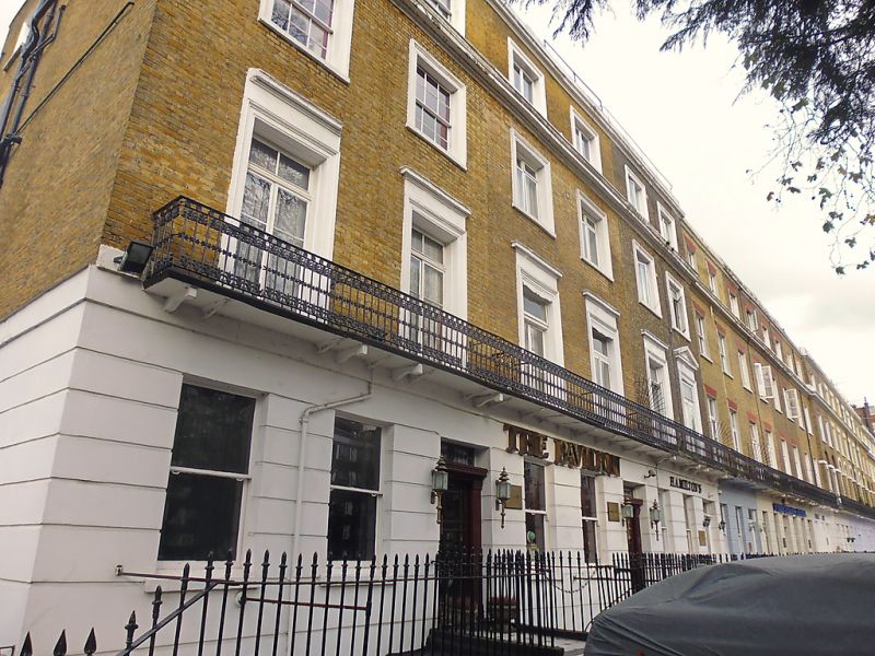
TQ 2781 NW CITY OF WESTMINSTER SUSSEX GARDENS, W2
42/17 and (north-west side)
TQ 2781 SW
53/17
5.2.70 Nos 6 to 36 (even)
GV II
Terrace. Early C19. Brown brick in Flemish bond, channelled stucco ground
floor, stucco cornice and further cornice to parapet. 4 storeys. Basement.
10-bay breakforward flanked by 8-bay wings and further 6-bay slight breakforward
to left end (presumably originally formed a symmetrical composition, the similar
6-bay breakforward to the right having been replaced by later building).
Pilastered entrances. Sash windows, some with glazing bars. 1st floor: iron
balcony. Casements or sashes, some with glazing bars. The windows to the
central breakforward have flat gauged brick arches and are set in
segmental-arched recesses with stucco imposts. Flat gauged brick arches to left
8-bay wing, otherwise stucco architraves. Above, mainly sashes with glazing
bars. Cornice at 3rd floor level. Iron railings to basement. Known originally
as Grand Junction Road, Sussex Gardens formed an important feature of the
original layout of Bayswater. No 32 was occupied in 1830-6 by B O'Meara
(Napoleon's surgeon on St Helena).
The London Encyclopedia, C Hibbert and B Weinreb (eds), p.46 and 348.
Listing NGR: TQ2717181471
External links are from the relevant listing authority and, where applicable, Wikidata. Wikidata IDs may be related buildings as well as this specific building. If you want to add or update a link, you will need to do so by editing the Wikidata entry.


Other nearby listed buildings
