Approximate Location Map
Large Map »
Latitude: 51.321 / 51°19'15"N
Longitude: 0.8973 / 0°53'50"E
OS Eastings: 601979
OS Northings: 161969
OS Grid: TR019619
Mapcode National: GBR SW3.5NF
Mapcode Global: VHKJW.H2Q5
Plus Code: 9F328VCW+9W
Entry Name: Warehouse About 30 Metres North East of Provender Mill (Gilletts Limited)
Listing Date: 27 September 1989
Grade: II
Source: Historic England
Source ID: 1240591
English Heritage Legacy ID: 438956
ID on this website: 101240591
Location: Faversham, Swale, Kent, ME13
County: Kent
District: Swale
Civil Parish: Faversham
Built-Up Area: Faversham
Traditional County: Kent
Lieutenancy Area (Ceremonial County): Kent
Tagged with: Warehouse
FAVERSHAM STANDARD QUAY
TR 0161 NE
F 99 1/374 Warehouse about 30 metres
north east of Provender
Mill (Gilletts Ltd)
Interior inspected
GV
II
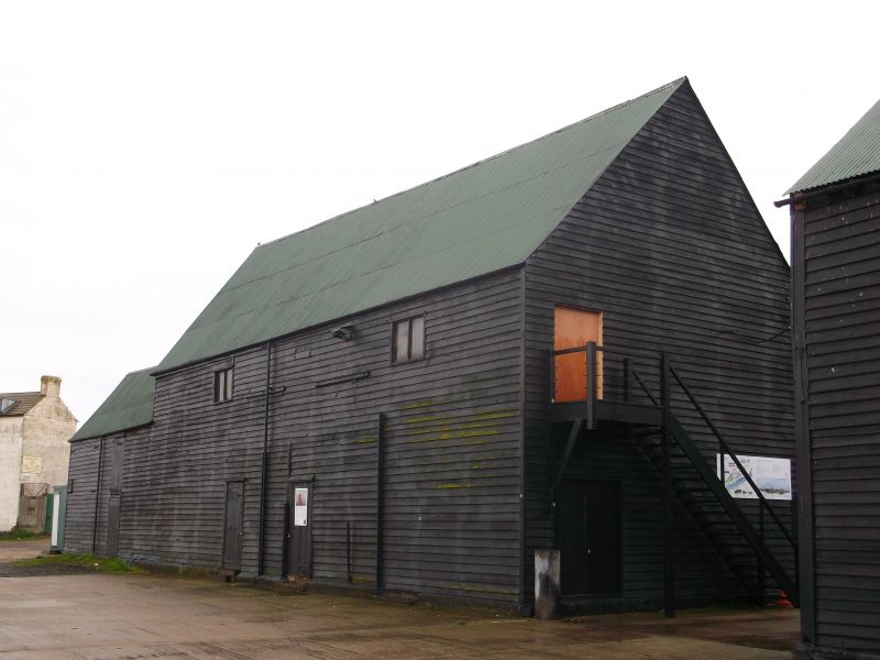
Warehouse. Early C19 in two phases. Timber framed and weather boarded with
corrugated iron roofing. Main block of two storeys on plinth with curbing
stones at the corners. Two boarded loft doors, to left and to right, the latter
with hoist beam projecting over, with shuttered window openings. Ground floor
with three boarded doors, and bricked section of wall to right with casement
window. Lower single storey and left extension recessed to right with small
lean-to and fenced compound, and with shuttered window in right return and
boarded doors on each floor to rear, quayside, elevation. Same elevation of
main block with window openings on first floor and single boarded door on ground
floor, the weather boarding presumably disguising other openings. Interior:
all-timber construction with timber posts carrying massive main beams, with
some inserted iron posts for additional support for milling machinery. Part
of an important complex of C18 and early C19 warehouses marked in situ on the
1841 Tithe Map and grouping with the Grade II* Provender Mill.
Listing NGR: TR0197961969
External links are from the relevant listing authority and, where applicable, Wikidata. Wikidata IDs may be related buildings as well as this specific building. If you want to add or update a link, you will need to do so by editing the Wikidata entry.


Other nearby listed buildings
