Approximate Location Map
Large Map »
Latitude: 51.2822 / 51°16'55"N
Longitude: 1.0759 / 1°4'33"E
OS Eastings: 614601
OS Northings: 158164
OS Grid: TR146581
Mapcode National: GBR TY2.GV4
Mapcode Global: VHLGM.L1MD
Plus Code: 9F3373JG+V9
Entry Name: 5, North Lane
Listing Date: 7 September 1973
Grade: II
Source: Historic England
Source ID: 1241117
English Heritage Legacy ID: 440043
ID on this website: 101241117
Location: Canterbury, Kent, CT2
County: Kent
District: Canterbury
Electoral Ward/Division: Westgate
Parish: Non Civil Parish
Built-Up Area: Canterbury
Traditional County: Kent
Lieutenancy Area (Ceremonial County): Kent
Tagged with: Building
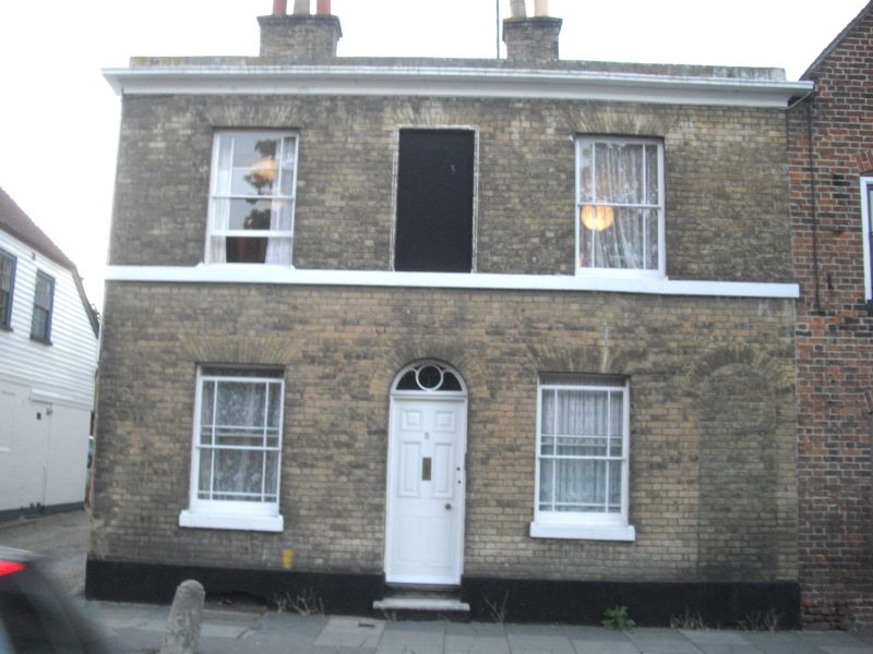
1.
944 N0RTH LANE
(North West Side)
No 5
TR 1458 SE 2/344
II GV
2.
Early C19. 2 storeys buff brick. Stone coping and stringcourse. 3 window
spaces. 2 sashes, 1 blank. Central round-headed doorcase with 6 fielded panelled
door. 2 stone steps.
Nos 1, 2 & Nos 4 to 15 (consec) form a group.
Listing NGR: TR1459858164
External links are from the relevant listing authority and, where applicable, Wikidata. Wikidata IDs may be related buildings as well as this specific building. If you want to add or update a link, you will need to do so by editing the Wikidata entry.


Other nearby listed buildings
