Approximate Location Map
Large Map »
Latitude: 50.5235 / 50°31'24"N
Longitude: -3.819 / 3°49'8"W
OS Eastings: 271151
OS Northings: 70883
OS Grid: SX711708
Mapcode National: GBR QD.GGN1
Mapcode Global: FRA 27WP.3Z4
Plus Code: 9C2RG5FJ+C9
Entry Name: New Bridge
Listing Date: 23 August 1955
Grade: II*
Source: Historic England
Source ID: 1241905
English Heritage Legacy ID: 441166
ID on this website: 101241905
Location: Teignbridge, Devon, TQ13
County: Devon
District: Teignbridge
Civil Parish: Holne
Traditional County: Devon
Lieutenancy Area (Ceremonial County): Devon
Church of England Parish: Holne St Mary the Virgin
Church of England Diocese: Exeter
Tagged with: Road bridge
WIDECOMBE-IN-THE-MOOR
SX 77 SW
6/193
New Bridge
23.8.55
II*
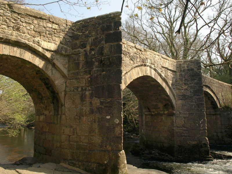
Bridge crossing River Dart. Believed to be C15, repaired in 1645.
Granite rubble, except for arch at the Holne end which is of ashlar; the piers are
of squared and coursed rubble up to springing level of the arches. Bridge consists
of two main arches across the river with a smaller third arch crossing the Widecombe
bank. The arches are rounded, except for the centre one which is very slightly
pointed. They have well-cut voussoirs, the masonry above projecting slightly on
chamfered corbels. On the underside the two main arches spring from chamfered
imposts. Both piers have sharply pointed cutwaters on each side, these forming
refuges on top. The parapets on the Holne side are of ashlar as far as the first
cutwater, sweeping outwards at the end to finish in low, oblong-section piers; the
rounded granite coping extends to one half of the first cutwater. On the Widecombe
side the parapets are of rubble, also sweeping outwards at the end, but here dying
away into the ground; the copings are of chamfered granite blocks.
Source: C Henderson and E Jervoise, Old Devon Bridges, 1938, p.33.
The asset was previously listed twice also at List entry 1147169.
This entry was removed from the List on 7th March 2016.
This entry was subject to a Minor Amendment on 8th March 2016.
Listing NGR: SX7115170883
External links are from the relevant listing authority and, where applicable, Wikidata. Wikidata IDs may be related buildings as well as this specific building. If you want to add or update a link, you will need to do so by editing the Wikidata entry.


Other nearby listed buildings
