Approximate Location Map
Large Map »
Latitude: 51.089 / 51°5'20"N
Longitude: -1.811 / 1°48'39"W
OS Eastings: 413334
OS Northings: 132208
OS Grid: SU133322
Mapcode National: GBR 510.QXX
Mapcode Global: FRA 7637.L9K
Plus Code: 9C3W35QQ+JJ
Entry Name: Dairy Cottage
Listing Date: 12 October 1972
Grade: II
Source: Historic England
Source ID: 1243245
English Heritage Legacy ID: 446900
ID on this website: 101243245
Location: Stratford sub Castle, Wiltshire, SP1
County: Wiltshire
Civil Parish: Salisbury
Built-Up Area: Salisbury
Traditional County: Wiltshire
Lieutenancy Area (Ceremonial County): Wiltshire
Church of England Parish: Stratford sub Castle St Lawrence
Church of England Diocese: Salisbury
Tagged with: Cottage
STRATFORD ROAD
1.
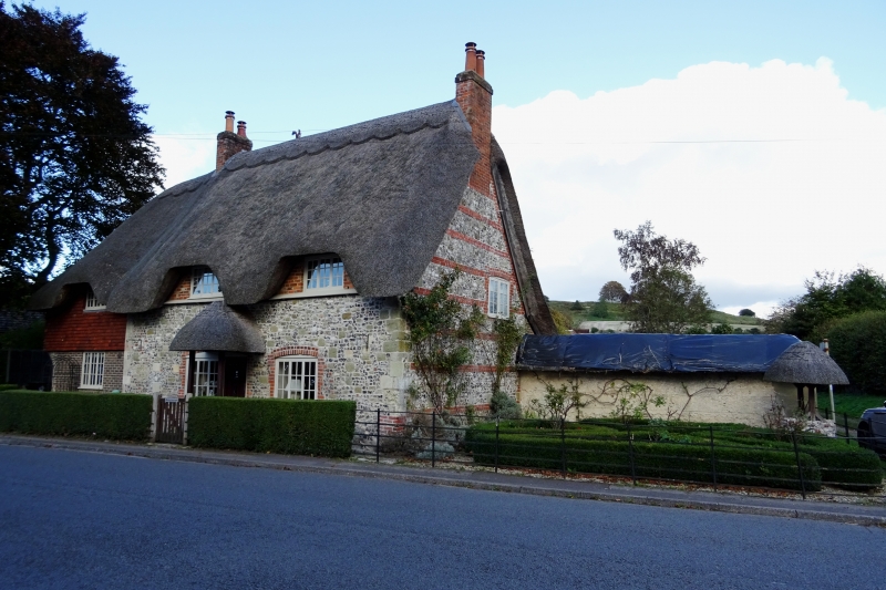
1594 Dairy Cottage
SU 1332 12/575
II GV
2.
Cl8. 2 storeys stone and flint with red brick dressings. Steep thatched roof
swept over upper windows. The upper semi-attic storey is brick. 2 3 light
casements and central thatched porch. Later lean-to with hipped tiled roof
to north.
Little Thatches and Old Forge Cottage form a group with Dairy Cottage.
Listing NGR: SU1333432208
External links are from the relevant listing authority and, where applicable, Wikidata. Wikidata IDs may be related buildings as well as this specific building. If you want to add or update a link, you will need to do so by editing the Wikidata entry.


Other nearby listed buildings
