Approximate Location Map
Large Map »
Latitude: 51.3385 / 51°20'18"N
Longitude: 0.1784 / 0°10'42"E
OS Eastings: 551837
OS Northings: 162183
OS Grid: TQ518621
Mapcode National: GBR T1.FN7
Mapcode Global: VHHPD.1MP9
Plus Code: 9F3285QH+99
Entry Name: Oxbourne Farmhouse
Listing Date: 16 January 1975
Grade: II
Source: Historic England
Source ID: 1243745
English Heritage Legacy ID: 447999
ID on this website: 101243745
Location: Shoreham, Sevenoaks, Kent, TN14
County: Kent
District: Sevenoaks
Civil Parish: Shoreham
Built-Up Area: Shoreham
Traditional County: Kent
Lieutenancy Area (Ceremonial County): Kent
Church of England Parish: Shoreham St Peter and St Paul
Church of England Diocese: Rochester
Tagged with: Farmhouse
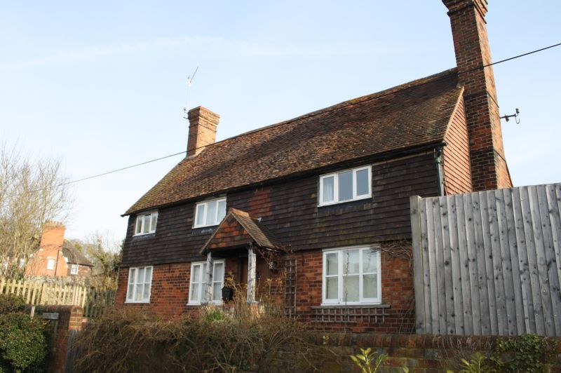
1.
5280 SHOREHAM SHOREHAM
Mill Lane
(North Side)
Oxbourne Farmhouse
TQ 5162 29/1204
II
2.
C16 or earlier timber framed farmhouse. 2 storeys, 3 windows. High pitched
tiled roof with end stacks. Tile hung 1st floor, brick ground floor. C19 casement
windows. Plain boarded door under hipped tiled hood. Much exposed timber inside.
Listing NGR: TQ5183762182
External links are from the relevant listing authority and, where applicable, Wikidata. Wikidata IDs may be related buildings as well as this specific building. If you want to add or update a link, you will need to do so by editing the Wikidata entry.


Other nearby listed buildings
