Approximate Location Map
Large Map »
Latitude: 51.2543 / 51°15'15"N
Longitude: -0.9375 / 0°56'14"W
OS Eastings: 474245
OS Northings: 151111
OS Grid: SU742511
Mapcode National: GBR C86.9SP
Mapcode Global: VHDXS.PQRS
Plus Code: 9C3X7337+P2
Entry Name: Gate Piers to No 31 and 33
Listing Date: 24 November 1961
Grade: II
Source: Historic England
Source ID: 1244131
English Heritage Legacy ID: 448934
ID on this website: 101244131
Location: Odiham, Hart, Hampshire, RG29
County: Hampshire
District: Hart
Civil Parish: Odiham
Built-Up Area: Odiham
Traditional County: Hampshire
Lieutenancy Area (Ceremonial County): Hampshire
Church of England Parish: Odiham All Saints
Church of England Diocese: Winchester
Tagged with: Gatepost
SU 73-7450 & 73-7451 ODIHAM HIGH STREET
(south side)
17/73
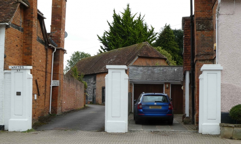
Gatepiers to No 31 and 33
-
GV II
Early C19. 3 piers, forming coupled gateways. Red brick, with rendered fronts,
recessed panel, plinth. Stone caps.
Listing NGR: SU7411851108
External links are from the relevant listing authority and, where applicable, Wikidata. Wikidata IDs may be related buildings as well as this specific building. If you want to add or update a link, you will need to do so by editing the Wikidata entry.


Other nearby listed buildings
