Approximate Location Map
Large Map »
Latitude: 50.7999 / 50°47'59"N
Longitude: -1.1068 / 1°6'24"W
OS Eastings: 463044
OS Northings: 100421
OS Grid: SU630004
Mapcode National: GBR VNJ.VR
Mapcode Global: FRA 86KZ.JMV
Plus Code: 9C2WQVXV+X7
Entry Name: Number 6 Boathouse (Building Number 1/23) and Slipway to Front
Listing Date: 13 August 1999
Grade: II*
Source: Historic England
Source ID: 1244594
English Heritage Legacy ID: 476648
Also known as: Number 6 Boathouse
ID on this website: 101244594
Location: Portsea, Portsmouth, Hampshire, PO1
County: City of Portsmouth
Electoral Ward/Division: Charles Dickens
Parish: Non Civil Parish
Built-Up Area: Portsmouth
Traditional County: Hampshire
Lieutenancy Area (Ceremonial County): Hampshire
Church of England Parish: St Thomas of Canterbury, Portsmouth
Church of England Diocese: Portsmouth
Tagged with: Architectural structure
SU 6300 SW COLLEGE ROAD
(Northwest side)
HM Naval Base
774-1/30/201 No.6 Boathouse (Building No 1/23)
and slipway to front
GV II*
Includes: No.6 Boathouse (Building No. 1/23) and slipway to front, MAIN ROAD HM NAVAL BASE
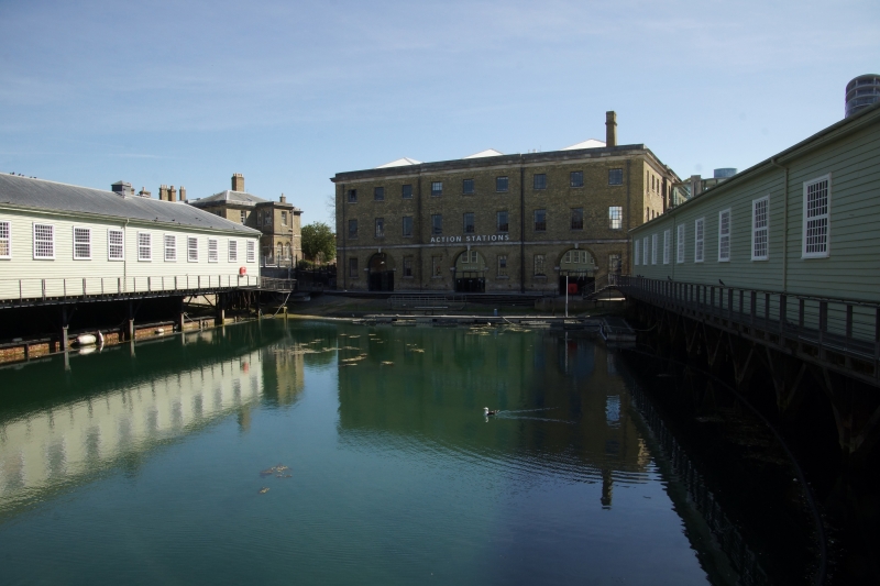
Mast house, then boathouse with slipway at front. 1845; bomb-damaged 1941. Designed by Captain RS Beatson RE, contractor Mr Rigby. Yellow brick in ashlar bond with ashlar dressings, with internal cast-iron frame. Replacement mid-late C20 corrugated iron roof with roof lights. EXTERIOR: 3 storeys, on west side the ground level being lower to give access to adjacent mast pond. 5-sided, the rectangular plan having diagonal wall built across south-east corner. The bomb damage was to the east end, where the building remains a shell with first-floor windows blocked and 2nd floor missing. Ashlar plinth, to west elevation; band over ground floor; eaves band and cornice. Windows have flat brick arches, projecting ashlar sills, and CZO replacement metal windows; they are shorter on ground and 2nd floors. Loading doors have eared ashlar architraves with tripartite keystones. West elevation: 9 bays, 3 central bays breaking forward. At centre of each 3-bay section a large round- arched entrance with imposts, keystones, studded double board doors, fanlights, and lamp on left of central door. Iron mooring rings at low level. A brick chimney rises behind parapet at right-hand corner, tapering and corniced. Slipway along front, sloping down to Mast Pond (qv), is of stone setts with iron mooring rings and a track of granite slabs with iron rollers leading up to each entrance of the boathouse (that leading to the right-hand entrance now built over). North elevation: 15 bays, with 2-bay end breaks and 3-bay central break which has a central loading door on each floor, now blocked. East elevation: 6 bays, with loading doors on each floor of bays Z and 5. South-east elevation: 5 bays with central loading doors. South-west elevation: 11 bays with central3-bay break which has central loading doors, that on 1st floor with crane. Double board door to ground floor of bay 3.
INTERIOR: cast-iron columns; cast-iron segmental-arched beams across shorter spans, and cast-iron trussed beams across wider spans. On 3rd floor, braced rivet ted steel roof trusses. Wooden floors. On ground floor, 3 slipways with a double row of columns between (14 columns to a row); above the central slipway the ceiling is open, to allow mast- fitting. At west end is a trap door, strengthened by Z extra columns.
HISTORY: designed by Beatson to take an exceptionally heavy load, and of interest with his other work at Portsmouth, the Fire Station and Chain Testing Shop (qqv). This must have been one of the last uses of trussed beams before the 1847 Dee Bridge disaster enquiry discredited their use. A contrasting design to the traditional timber 1844 Lower Boat House at Chatham, and the innovative 1859 Boat store at Sheerness designed by GT Greene. Boats could be lifted internally through to the upper floors. Lloyd (1974) observes that "This is one of the earliest buildings where load-bearing iron-framed construction is used on such a massive scale, and with such sophistication".
(Sources: The Buildings of England: Lloyd D: Hampshire and the Isle of Wight: Harmondsworth: 1985: 410 ; Portsmouth Naval Base Property Trust: Naval Heritage at Portsmouth, Visitor's Guide: Portsmouth: 1988; Lloyd DW: Buildings of Portsmouth and its Environs: Portsmouth: 1974: 72).
SU 6300 SW MAIN ROAD
(East side)
HM Naval Base
774-1/30/201 No 6 Boathouse (Building No 1/23)
and slipway to front
GV II*
See under: No.6 Boathouse (Building No. 1/23) and slipway to front, COLLEGE ROAD HM NAVAL BASE
Listing NGR: SU6299200361
External links are from the relevant listing authority and, where applicable, Wikidata. Wikidata IDs may be related buildings as well as this specific building. If you want to add or update a link, you will need to do so by editing the Wikidata entry.


Other nearby listed buildings
