Approximate Location Map
Large Map »
Latitude: 54.4673 / 54°28'2"N
Longitude: -3.0345 / 3°2'4"W
OS Eastings: 333050
OS Northings: 508486
OS Grid: NY330084
Mapcode National: GBR 7J7S.VC
Mapcode Global: WH81Z.CZ85
Plus Code: 9C6RFX88+W6
Entry Name: Lancrigg
Listing Date: 15 March 1974
Grade: II
Source: Historic England
Source ID: 1245190
English Heritage Legacy ID: 452088
ID on this website: 101245190
Location: Westmorland and Furness, Cumbria, LA22
County: Cumbria
District: South Lakeland
Civil Parish: Lakes
Traditional County: Westmorland
Lieutenancy Area (Ceremonial County): Cumbria
Church of England Parish: Grasmere St Oswald
Church of England Diocese: Carlisle
Tagged with: Building
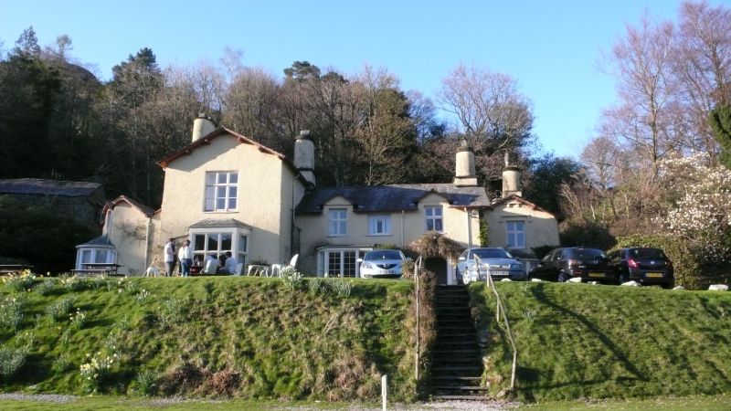
1.
1291A GRASMERE
Lancrigg
NY 30 NW 7/72
II
2.
C17 with C19 additions and alterations. Coloured roughcast over stone
rubble, slate roof with round chimneys, thick volts panelled reveals.
Interior has some Tudor arches in the hall etc. Old farmhouse modernised
circa 1850.
Listing NGR: NY3305008486
External links are from the relevant listing authority and, where applicable, Wikidata. Wikidata IDs may be related buildings as well as this specific building. If you want to add or update a link, you will need to do so by editing the Wikidata entry.


Other nearby listed buildings
