Approximate Location Map
Large Map »
Latitude: 53.4825 / 53°28'56"N
Longitude: -2.2326 / 2°13'57"W
OS Eastings: 384663
OS Northings: 398444
OS Grid: SJ846984
Mapcode National: GBR DMG.8M
Mapcode Global: WHB9G.PQ2M
Plus Code: 9C5VFQJ8+XX
Entry Name: Former Newton Street Police Station
Listing Date: 6 June 1994
Grade: II
Source: Historic England
Source ID: 1246269
English Heritage Legacy ID: 454814
Also known as: Manchester Police Museum
ID on this website: 101246269
Location: Ancoats, Manchester, Greater Manchester, M1
County: Manchester
Electoral Ward/Division: Ancoats and Clayton
Parish: Non Civil Parish
Built-Up Area: Manchester
Traditional County: Lancashire
Lieutenancy Area (Ceremonial County): Greater Manchester
Church of England Parish: Manchester Cathedral
Church of England Diocese: Manchester
Tagged with: Museum Archive Police station Police museum Local authority museum
This list entry was subject to a Minor Amendment on 02/03/2020
SJ8498SE
698-1/29/254
MANCHESTER
NEWTON STREET (north west side)
No.57A, Greater Manchester Police Museum
Former Newton Street Police Station
(Formerly listed as former Newton Street Police Station, No.57A,NEWTON STREET (North West side))
GV
II
Police station, now police museum. 1879 by J.H Lynde, altered 1902 by City Surveyor. Red brick in English bond with sandstone dressings and slate roof. L-shaped with principal facade to Newton Street and long Faraday Street façade.
Two storeys and four bays with plinth, alternating ground-floor quoins to street angle, broad band over ground floor, first-floor sill-band, string course, parapet with prominent moulded cornice and blocking course. Round-headed doorway to second bay, with moulded surround including keystone and fluted consoles to a pediment on the band, panelled door with lion knockers and carved city arms in tympanum. Window over the door is narrower, all windows segmental-headed with drip-moulds, stone imposts and keystones. Wooden mullion-and-transom glazing incorporating sliding sashes. Partially-embedded cast-iron downpipes at left and between bays 3 and 4.
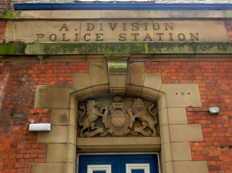
Seven-bay return to Faraday Street with a short return of the cornice and string course, and similar details with windows to both floors alternately narrow and wide. Then a single-storey continuation with very tall rectangular panelled and corniced chimney stack set back and spanning the junction. The plinth and bands continue and there is a segmental-headed doorway with quoined surround and city arms in tympanum, with stone above the band inscribed ‘A. DIVISION/ POLICE STATION'. Alternating quoins to the angle with Little Lever Street.
History: originally built as a defensible building comprising a linear range fronting Faraday Street (still Friday Street in 1891), with rear outshut to east of centre, and detached mortuary in rear yard surrounded by a high wall (also to Newton Street). The largely-blind west end of the Faraday Street façade indicates the original appearance of the whole. Central chimney first marked on 1922 1:2,500 Ordnance Survey (OS) map but thought to be original. The station was substantially rebuilt in 1902. The wing towards Newton Street, with male cells, parade room above and rear outshut, was replaced by the L-shaped, two-storey weights and measures office and workshop, with a glazed courtyard behind. The rear outshut was removed at ground floor with the first floor supported on columns in the courtyard. A new outshut was added to the west of centre for the charge office. A new parade room was built over the surviving (female) cell wing.
The police station closed in 1979 and was converted to a museum in 1981. In 2000, the rescued interior of Denton Police Court (1895) was installed in the 1902 parade room. The mortuary in the rear yard was demolished in the late-C20.
Listing NGR: SJ8466398444
External links are from the relevant listing authority and, where applicable, Wikidata. Wikidata IDs may be related buildings as well as this specific building. If you want to add or update a link, you will need to do so by editing the Wikidata entry.


Other nearby listed buildings
