Approximate Location Map
Large Map »
Latitude: 53.3901 / 53°23'24"N
Longitude: -1.5242 / 1°31'26"W
OS Eastings: 431743
OS Northings: 388242
OS Grid: SK317882
Mapcode National: GBR 93G.PK
Mapcode Global: WHCCJ.K1FX
Plus Code: 9C5W9FRG+28
Entry Name: Roscoe Bridge
Listing Date: 12 December 1995
Grade: II
Source: Historic England
Source ID: 1247139
English Heritage Legacy ID: 456362
ID on this website: 101247139
Location: Liberty Hill, Sheffield, South Yorkshire, S6
County: Sheffield
Electoral Ward/Division: Stannington
Parish: Non Civil Parish
Built-Up Area: Sheffield
Traditional County: Yorkshire
Lieutenancy Area (Ceremonial County): South Yorkshire
Church of England Parish: Crookes St Timothy
Church of England Diocese: Sheffield
Tagged with: Bridge
SHEFFIELD
SK38NW RIVELIN VALLEY ROAD
784-1/5/626 (North side (off))
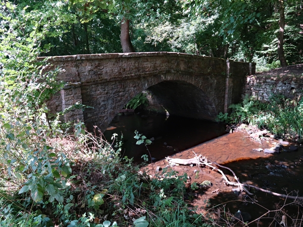
Roscoe Bridge
II
Road bridge spanning the River Rivelin. Early C19. Coursed
squared stone. Segmental arch with string course. Parapet
walls with slab coping and square piers with flat caps. Pair
of round-headed stone gateposts at the north-west end.
Listing NGR: SK3174388242
External links are from the relevant listing authority and, where applicable, Wikidata. Wikidata IDs may be related buildings as well as this specific building. If you want to add or update a link, you will need to do so by editing the Wikidata entry.


Other nearby listed buildings
