Approximate Location Map
Large Map »
Latitude: 51.6225 / 51°37'20"N
Longitude: 0.5701 / 0°34'12"E
OS Eastings: 578006
OS Northings: 194647
OS Grid: TQ780946
Mapcode National: GBR PM1.6YT
Mapcode Global: VHJKP.THR1
Plus Code: 9F32JHCC+X2
Entry Name: Old Tide Mill and Dam Wall Attached to North
Listing Date: 11 March 1991
Grade: II
Source: Historic England
Source ID: 1247782
English Heritage Legacy ID: 429152
ID on this website: 101247782
Location: Battlesbridge, Chelmsford, Essex, SS11
County: Essex
District: Rochford
Civil Parish: Rawreth
Built-Up Area: Battlesbridge
Traditional County: Essex
Lieutenancy Area (Ceremonial County): Essex
Church of England Parish: Rettendon All Saints
Church of England Diocese: Chelmsford
Tagged with: Mill building
The following item shall be added:
RETTENDON OFF CHELMSFORD ROAD
TQ 79 SE BATTLESBRIDGE.
21/952 (West Side)
Old tide Mill and
GV Dam wall attached
to north.
II.
This asset was previously listed twice under List entry 1322349. This entry was removed from the list on 01/12/2014.
Partly situated in Rawreth in the Parish of Rayleigh, Rochford.
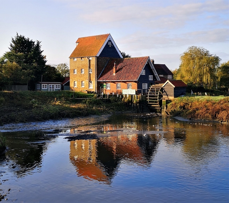
Former tide mill, now used as a warehouse with attached. offices. Late C18.
Brick built. Red plain tiled roof. South Weatherboarded lucam and gable. The
north gable facing the River Crouch with attached dam wall. 3 storeys and loft.
3 window range to return wall s of- mainly vertically sliding sashes with glazing
bars. Various tie plates. Bargeboards to gable. 2 light window to lucam. Tall
double vertically boarded doors to ground and first floors, the latter with
segmental head. Attached to west and included for group value is a lower range L
plan outbuilding with red pantiled roofs. The gabled southern range with five 3
light windows, segmental arches to right return. 2 window range and chimney stack
to gable -end. The dam wall, mainly of red brick with stone coping with openings for
the tide control gates extends to north, crossing the River Crouch. Even though not now a working mill, a rare survival in Essex. Batsford Guide to Industrial
Archaeology in East Anglia. J. Booker.
Listing NGR: TQ780069647
External links are from the relevant listing authority and, where applicable, Wikidata. Wikidata IDs may be related buildings as well as this specific building. If you want to add or update a link, you will need to do so by editing the Wikidata entry.


Other nearby listed buildings
