Approximate Location Map
Large Map »
Latitude: 52.2435 / 52°14'36"N
Longitude: 0.7145 / 0°42'52"E
OS Eastings: 585424
OS Northings: 264064
OS Grid: TL854640
Mapcode National: GBR QF0.7GY
Mapcode Global: VHKD4.BVLZ
Plus Code: 9F426PV7+CR
Entry Name: Tools and Things
Listing Date: 12 July 1972
Last Amended: 30 October 1997
Grade: II
Source: Historic England
Source ID: 1248116
English Heritage Legacy ID: 466705
ID on this website: 101248116
Location: Bury St Edmunds, West Suffolk, IP33
County: Suffolk
District: West Suffolk
Civil Parish: Bury St Edmunds
Built-Up Area: Bury St Edmunds
Traditional County: Suffolk
Lieutenancy Area (Ceremonial County): Suffolk
Church of England Parish: Bury St Edmunds St Mary
Church of England Diocese: St.Edmundsbury and Ipswich
Tagged with: Architectural structure
BURY ST EDMUNDS
TL8564SW CHURCHGATE STREET
639-1/14/238 (North side)
12/07/72 No.21
(Formerly Listed as:
HATTER STREET
Nos.11 AND 12)
(Formerly Listed as:
CHURCHGATE STREET
No.21)
GV II
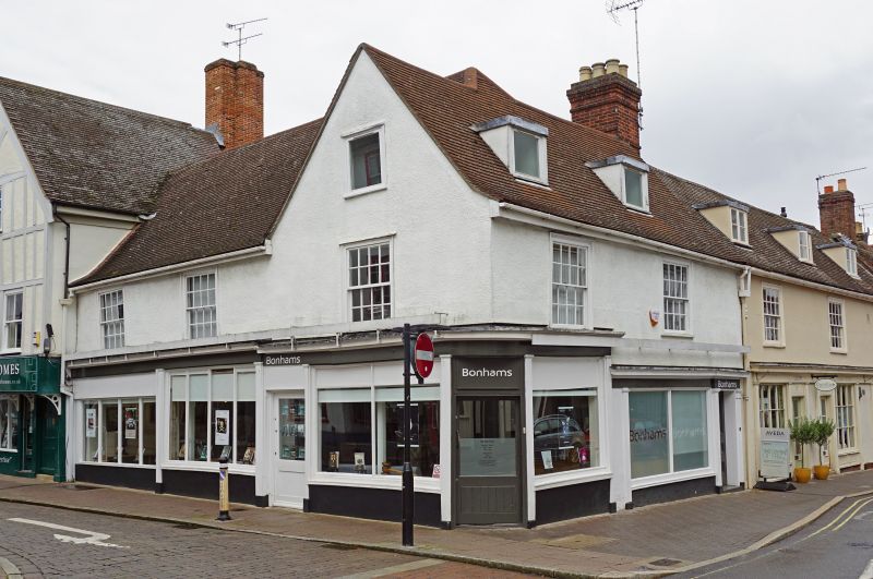
Includes: No.11 Tools and Things HATTER STREET.
Shop, formerly a house and shop. C17 with an earlier core and
later alterations. Timber-framed and rendered with C20
plaintiles: an L-shaped building, in 2 separate ranges, on a
corner site with a return front to Hatter Street. The roof of
the Hatter Street range tops over the Churchgate range, which
has a gable end facing Hatter Street.
EXTERIOR: 2 storeys and attics. 2 windows on Churchgate
Street: 16-pane sashes in flush cased frames; 3 similar
windows on Hatter Street. 2 flat-headed dormers with C20
fenestration to Churchgate Street. The ground storey has a C20
shop front.
INTERIOR: the 2 ranges of the building have been occupied as
separate dwellings, but were probably part of one house
originally. The Churchgate Street range, in 3 bays, has most
of its timbers covered or boxed-in, with the exception of one
trimmer which has a very wide chamfer and broach stops,
suggesting a late C15/early C16 date. The Hatter Street range,
in 2 bays, was formerly jettied and has an exposed
early-to-mid C16 ceiling to the ground storey, the main
cross-beams with a roll-and-hollow moulding and run-off stops,
the joists ogee-moulded. The rear (east) wall has been removed
for a later extension, but a beam with embattled ornament
remains at ceiling height.
In the southern of the 2 bays is a good blocked stair-trap
with moulded surrounds to the former opening. No exposed
timbers on the upper storey or the roof, which may well have
been replaced in conjunction with creating an attic storey.
Listing NGR: TL8542464064
External links are from the relevant listing authority and, where applicable, Wikidata. Wikidata IDs may be related buildings as well as this specific building. If you want to add or update a link, you will need to do so by editing the Wikidata entry.


Other nearby listed buildings
