Approximate Location Map
Large Map »
Latitude: 52.2434 / 52°14'36"N
Longitude: 0.7155 / 0°42'55"E
OS Eastings: 585495
OS Northings: 264053
OS Grid: TL854640
Mapcode National: GBR QF0.7QN
Mapcode Global: VHKD4.CW42
Plus Code: 9F426PV8+96
Entry Name: The Queens Head Public House
Listing Date: 12 July 1972
Grade: II
Source: Historic England
Source ID: 1248211
English Heritage Legacy ID: 466719
ID on this website: 101248211
Location: Bury St Edmunds, West Suffolk, IP33
County: Suffolk
District: West Suffolk
Civil Parish: Bury St Edmunds
Built-Up Area: Bury St Edmunds
Traditional County: Suffolk
Lieutenancy Area (Ceremonial County): Suffolk
Church of England Parish: Bury St Edmunds St Mary
Church of England Diocese: St.Edmundsbury and Ipswich
Tagged with: Pub
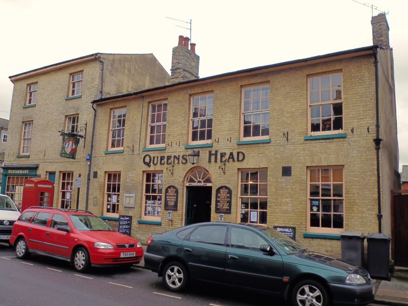
BURY ST EDMUNDS
TL8564SW CHURCHGATE STREET
639-1/14/252 (South side)
12/07/72 Nos.38A AND 39
The Queen's Head Public House
GV II
2 buildings: No.38A formerly a house and shop, but now linked
with No.39 as a public house. Mid C19 with an older core.
White brick and slates.
EXTERIOR: 3 storeys to No.38A; on a corner site. 2 window
range to both fronts: sashes in plain reveals with flat gauged
arches and projecting stone sills, 12-pane to the 1st storey,
9-pane to the 2nd. Between the 2 fronts, a splayed corner
which has a C20 shop front to the ground storey in traditional
style, with 2 small-paned windows flanking a half-glazed
entrance door below a moulded fascia. To each side of the shop
front is a 12-pane sash window and, on the Churchgate Street
front, a door. No.39 is 2-storey with extensive cellars. 5
window range: 12-pane sashes to both storeys, all in deep
reveals with flat gauged arches and projecting stone sills.
The central doorway has a plain semicircular brick arch,
fanlight with a fan motif and a half-glazed door with 2
leaves.
INTERIOR: the cellars have some walling of kidney flint and
stone blocks but are mainly of C19 brick. On the ground storey
of both parts of the building boxed-in beams indicate a timber
core to the structure, but nothing is visible above ground
storey level and both roofs have been replaced.
Listing NGR: TL8549564053
External links are from the relevant listing authority and, where applicable, Wikidata. Wikidata IDs may be related buildings as well as this specific building. If you want to add or update a link, you will need to do so by editing the Wikidata entry.


Other nearby listed buildings
