Approximate Location Map
Large Map »
Latitude: 51.896 / 51°53'45"N
Longitude: -1.4792 / 1°28'45"W
OS Eastings: 435935
OS Northings: 222063
OS Grid: SP359220
Mapcode National: GBR 6TF.4TR
Mapcode Global: VHBZH.9LWX
Plus Code: 9C3WVGWC+98
Entry Name: Cross
Listing Date: 27 August 1957
Grade: II*
Source: Historic England
Source ID: 1251432
English Heritage Legacy ID: 434138
Also known as: Taston village cross
ID on this website: 101251432
Location: Taston, West Oxfordshire, OX7
County: Oxfordshire
District: West Oxfordshire
Civil Parish: Spelsbury
Traditional County: Oxfordshire
Lieutenancy Area (Ceremonial County): Oxfordshire
Church of England Parish: Spelsbury
Church of England Diocese: Oxford
Tagged with: Monumental cross Stone cross
SPELSBURY TASTON
SP32SE
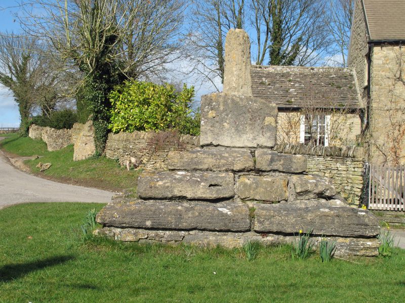
8/179 Cross
27/08/57
II*
Village cross. Medieval. Limestone. Tapering octagonal shaft, approximately 1.0
metres high, rises from a square base on a large square 3-step plinth. Scheduled
as an Ancient Monument.
(Buildings of England: Oxfordshire: p776)
Listing NGR: SP3593522063
External links are from the relevant listing authority and, where applicable, Wikidata. Wikidata IDs may be related buildings as well as this specific building. If you want to add or update a link, you will need to do so by editing the Wikidata entry.


Other nearby listed buildings
