Approximate Location Map
Large Map »
Latitude: 50.9533 / 50°57'11"N
Longitude: 0.7352 / 0°44'6"E
OS Eastings: 592203
OS Northings: 120661
OS Grid: TQ922206
Mapcode National: GBR RZ1.0PQ
Mapcode Global: FRA D6FL.87K
Plus Code: 9F22XP3P+83
Entry Name: 6, Landgate
Listing Date: 11 September 1972
Grade: II
Source: Historic England
Source ID: 1251772
English Heritage Legacy ID: 434570
ID on this website: 101251772
Location: Rye, Rother, East Sussex, TN31
County: East Sussex
District: Rother
Civil Parish: Rye
Built-Up Area: Rye
Traditional County: Sussex
Lieutenancy Area (Ceremonial County): East Sussex
Church of England Parish: Rye
Church of England Diocese: Chichester
Tagged with: Building
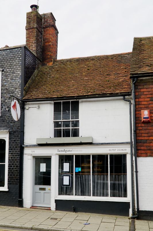
1.
1578 LANDGATE
(West Side)
No 6
TQ 9220 1/229
II GV
C19 facade probably to an earlier building. 2 storeys. 1 window. Stucco
grooved to imitate masonry. Tiled roof. Sash window. Early C19 shop
front with narrow pilasters, entablature with cornice.
Nos 4 to 7 (consec) and Nos 10 to 13 (consec) form a group.
Listing NGR: TQ9219920658
External links are from the relevant listing authority and, where applicable, Wikidata. Wikidata IDs may be related buildings as well as this specific building. If you want to add or update a link, you will need to do so by editing the Wikidata entry.


Other nearby listed buildings
