Approximate Location Map
Large Map »
Latitude: 50.9493 / 50°56'57"N
Longitude: -2.7158 / 2°42'56"W
OS Eastings: 349815
OS Northings: 116899
OS Grid: ST498168
Mapcode National: GBR MK.NHSQ
Mapcode Global: FRA 566L.MSP
Plus Code: 9C2VW7XM+PM
Entry Name: The Milk House
Listing Date: 19 April 1961
Grade: II
Source: Historic England
Source ID: 1252012
English Heritage Legacy ID: 434933
ID on this website: 101252012
Location: Montacute, Somerset, TA15
County: Somerset
District: South Somerset
Civil Parish: Montacute
Built-Up Area: Montacute
Traditional County: Somerset
Lieutenancy Area (Ceremonial County): Somerset
Tagged with: House
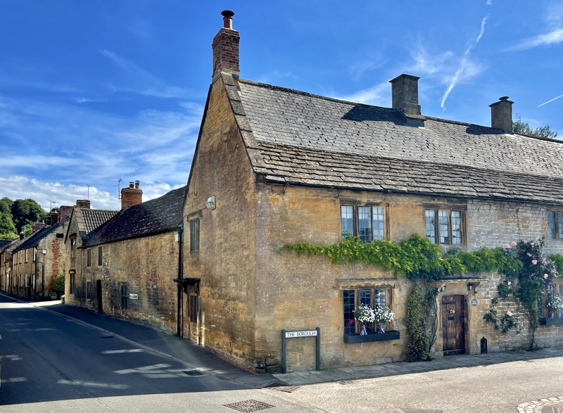
ST4916 MONTACUTE CP THE BOROUGH (South side)
8/113 No. 17
(The Milk House)
19.4.61
GV II
Semi-detached house, possibly divided formerly, now house and restaurant. C17 and later. Ham stone ashlar, with some
cut and squared work; main block has Welsh slate roof over stone slate base courses, with stepped coped east gable and
continuation to west; brick chimney stacks on stone bases. 'L'-plan; 2 storeys with attic, 3-bay north elevation.
Hollow- chamfer mullioned windows of 3 lights set in chamfered recesses, with labels to lower windows, all windows
having rectangular leaded panes; to lower bay 2 a near-triangular chamfered arched doorway with old boarded door under
stone hood on corbel brackets, with footscraper to right: bays 1 and 2 are ashlar, bay 3 rougher work. East gable has
similar doorway and hood, partly blocked and a window inserted; to first floor a 2-light mullioned window with label,
and blocked oculus window to attic. Lower extension to rear under double Roman clay tiled roof, in two sections; the
first in rubble stonework having a blocked doorway with timber lintol, then a cruciform chamfered mullioned and
transomed window under label, with 'Milk House' incised on lintol (to avoid paying window tax)- this section apparently
later raised in height; second section modified in C20; 2 bays of 2-light plain mullioned windows, with cambered-arched
doorway with pair boarded doors lower bay 2. Interior not seen.
Listing NGR: ST4981316881
External links are from the relevant listing authority and, where applicable, Wikidata. Wikidata IDs may be related buildings as well as this specific building. If you want to add or update a link, you will need to do so by editing the Wikidata entry.


Other nearby listed buildings
