Approximate Location Map
Large Map »
Latitude: 52.3985 / 52°23'54"N
Longitude: 0.2584 / 0°15'30"E
OS Eastings: 553749
OS Northings: 280230
OS Grid: TL537802
Mapcode National: GBR M6H.L4J
Mapcode Global: VHHJ6.FZG6
Plus Code: 9F4297X5+99
Entry Name: 29A, St Mary's Street
Listing Date: 19 June 1972
Grade: II
Source: Historic England
Source ID: 1252296
English Heritage Legacy ID: 435272
ID on this website: 101252296
Location: Ely, East Cambridgeshire, CB7
County: Cambridgeshire
District: East Cambridgeshire
Civil Parish: Ely
Built-Up Area: Ely
Traditional County: Cambridgeshire
Lieutenancy Area (Ceremonial County): Cambridgeshire
Church of England Parish: Ely
Church of England Diocese: Ely
Tagged with: Building
ST MARY'S STREET
1.
1082
(South Side)
No 29A
TL 5380 4/212
II GV
2.
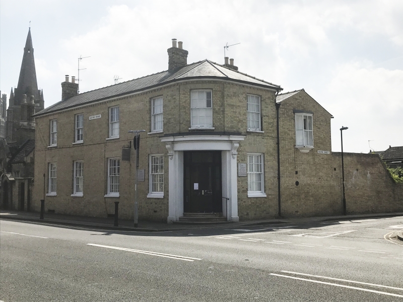
An early C19 buff coloured gault brick building with a quadrant corner
on the junction between St Mary's Street and Silver Street. 2 storeys
and cellars 4 window range on the north front, 1 window range on the
quadrant corner, slightly recessed on the 1st storey and 1 window range
on the west front, double-hung sashes with glazing bars, in plain reveals.
There is a wide doorway on the quadrant corner with curved double doors
and a stucco doorcase with pilasters and a cornice on console brackets.
A short wing at the south and lies an oriel bay window. Roof slate.
Nos 13 to 29 (odd) and 29A, Parson's Almshouses form a group with Nos 20,
22. 22A, Nos 24 to 30 (even), Nos 34, 36, 36A, 38, Nos 40 to 60 (even),
No 20 Church Lane and Parish Church of St Mary.
Also Nos 13 o 29 (odd) 29A Parson's Almshouses & Nos 20, 22, 22A, Nos 24 to 30
(even), Nos 34, 36, 36A, 38 & Nos 40 to 60 (even) form a group with Nos 1 to 5
Downham Road.
Listing NGR: TL5374980230
External links are from the relevant listing authority and, where applicable, Wikidata. Wikidata IDs may be related buildings as well as this specific building. If you want to add or update a link, you will need to do so by editing the Wikidata entry.


Other nearby listed buildings
