Approximate Location Map
Large Map »
Latitude: 50.2401 / 50°14'24"N
Longitude: -5.1842 / 5°11'2"W
OS Eastings: 173049
OS Northings: 42643
OS Grid: SW730426
Mapcode National: GBR Z6.0WX8
Mapcode Global: FRA 081D.654
Plus Code: 9C2P6RR8+28
Entry Name: 2 to 26 and 27-28 Mills Street, attached rear garden wall and outhouses
Listing Date: 15 October 1993
Last Amended: 21 January 1994
Grade: II
Source: Historic England
Source ID: 1253198
English Heritage Legacy ID: 436351
ID on this website: 101253198
Location: St Day, Cornwall, TR16
County: Cornwall
Civil Parish: St. Day
Built-Up Area: St Day
Traditional County: Cornwall
Lieutenancy Area (Ceremonial County): Cornwall
Church of England Parish: St Day
Church of England Diocese: Truro
Tagged with: Building
This list entry was subject to a Minor Amendment on 16/04/2020
SW 74 SW
11/10006
ST DAY
MILLS STREET (South side)
Nos. 2 to 26 (Even) and 27-28 and attached rear garden wall and outhouses
GV
II
Row of fifteen houses. Mostly early 1840s, with some houses completed later in decade. Nos 27-28 of coursed rubble with granite lintels and quoins and Nos 2 and 4 of brick with granite quoins and lintels; otherwise of coursed and dressed granite; gabled artificial slate roofs with brick stacks. Mostly single-depth plans with rear outshots; one mid C20 flat-roofed rear extension.
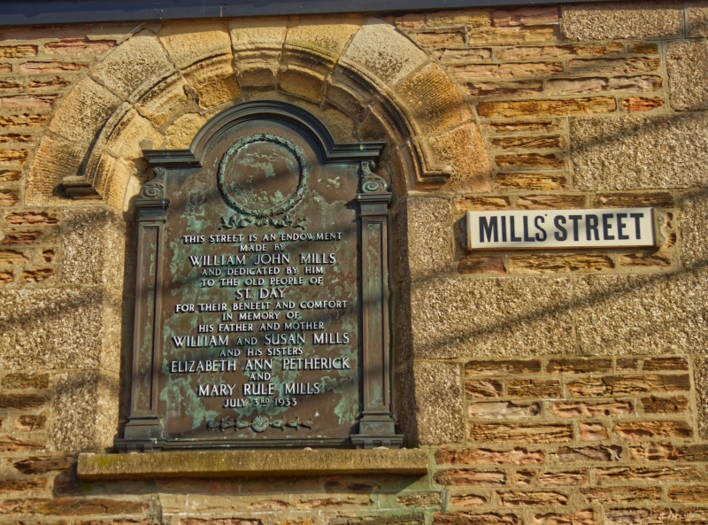
Two storeys; twenty four-window first-floor range. Granite lintels over two/two-pane sashes (originally four/four-pane but with horizontal glazing bars removed) and over C20 doors except original six-panel doors with narrow overlights to Nos 2, 12-18 and 24; No 4 is a larger double-fronted house. Nos 27 and 28 have copper plaque and wreath to first-floor centre commemorating endowment of this street by William John Mills "to the old people of St Day for their benefit and comfort".
Interior said to include original joinery and stick-baluster staircases with turned newels.
Subsidiary Features: rubble rear garden walls with slate-roofed former privies.
With Nos 1-25 (qv) these form an exceptionally well-preserved row of workers' housing, Mills Street having been built for the accommodation of miners in the surrounding orefields.
Listing NGR: SW7304942643
External links are from the relevant listing authority and, where applicable, Wikidata. Wikidata IDs may be related buildings as well as this specific building. If you want to add or update a link, you will need to do so by editing the Wikidata entry.


Other nearby listed buildings
