Approximate Location Map
Large Map »
Latitude: 51.6223 / 51°37'20"N
Longitude: -1.3274 / 1°19'38"W
OS Eastings: 446657
OS Northings: 191712
OS Grid: SU466917
Mapcode National: GBR 7Z8.76V
Mapcode Global: VHCYC.YH36
Plus Code: 9C3WJMCF+W2
Entry Name: Causeway Farmhouse and Causeway Cottage
Listing Date: 26 August 1994
Grade: II
Source: Historic England
Source ID: 1253342
English Heritage Legacy ID: 436508
ID on this website: 101253342
Location: Steventon, Vale of White Horse, Oxfordshire, OX13
County: Oxfordshire
District: Vale of White Horse
Civil Parish: Steventon
Built-Up Area: Steventon
Traditional County: Berkshire
Lieutenancy Area (Ceremonial County): Oxfordshire
Church of England Parish: Steventon
Church of England Diocese: Oxford
Tagged with: Farmhouse
This list entry was subject to a Minor Amendment on 12/09/2012
SU4691
1710-0/12/10001
THE CAUSEWAY
(North West side)
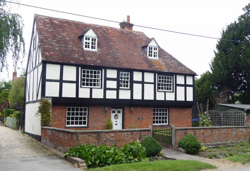
Causeway Farmhouse and Causeway Cottage
(Formerly listed as Causeway Farmhouse and outbuilding attached to north west)
GV
II
Farmhouse. Circa early C17, extended in circa C18 and altered in C19. Timber-framed,
partly rebuilt in brick, roughcast and applied sham framing, extended in stone rubble and
brick. Plain tile roof with gabled ends and hipped corner. Brick axial and lateral stacks.
PLAN: Jettied front range of 2 room plan and with doorway to left of centre. Wing behind
right hand end possibly of same date with C18 and C19 extensions on its south west side
and an outbuilding on the north west end. EXTERIOR: 2 storeys and attic. Asymmetrical
2-window south east front, ground floor red brick and first floor jettied out on shaped
brackets, rendered and with applied sham timber-framing; C19 20-pane sashes and doorway
to left of centre with 6-panel door; 2 small gabled dormers with C20 casements. South west
side of rear wing has stone rubble gabled extension on left and brick infil at centre. North
east side roughcast and painted brick and with various casements and small gabled dormer.
Rear outbuilding on right has one bay with exposed timber framing, the remainder brick
and partly weatherboarded. INTERIOR: Main south east front range only attic inspected;
this is ceiled but has exposed 5-bay roof structure with two tiers of purlins, the upper purlins
clasped above high collars, the lower purlins are butted [tenoned] to the principals; straight
wind-braces. Rear wing has partition with curved braces to tie-beam and large purlins
clasped over collars; ground floor room of rear wing has chamfered axial and cross-beams and
exposed joists.
Listing NGR: SU4665791712
External links are from the relevant listing authority and, where applicable, Wikidata. Wikidata IDs may be related buildings as well as this specific building. If you want to add or update a link, you will need to do so by editing the Wikidata entry.


Other nearby listed buildings
