Approximate Location Map
Large Map »
Latitude: 52.7095 / 52°42'34"N
Longitude: -2.7589 / 2°45'32"W
OS Eastings: 348821
OS Northings: 312697
OS Grid: SJ488126
Mapcode National: GBR BJ.27H8
Mapcode Global: WH8BT.L5F4
Plus Code: 9C4VP65R+RC
Entry Name: The Armoury
Listing Date: 27 January 1994
Grade: II
Source: Historic England
Source ID: 1254936
English Heritage Legacy ID: 458392
ID on this website: 101254936
Location: Frankwell, Shropshire, SY1
County: Shropshire
Civil Parish: Shrewsbury
Built-Up Area: Shrewsbury
Traditional County: Shropshire
Lieutenancy Area (Ceremonial County): Shropshire
Church of England Parish: Shrewsbury St Chad
Church of England Diocese: Lichfield
Tagged with: Barracks
This List entry was subject to a Minor Amendment on 04/07/2019
SJ 4812 NE
653-1/10/687
SHREWSBURY
VICTORIA AVENUE (south side),
VICTORIA QUAY
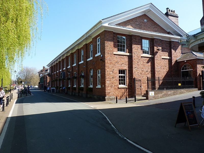
The Armoury
(Formerly listed as Former Bakery, VICTORIA AVENUE, previously listed as Bakery)
27/01/94
GV
II
Former barracks, later rebuilt as a bakery and renovated in 1995 as a public house. Originally built 1806 as barracks by James Wyatt for Shrewsbury Armoury, on a site adjacent to London Road, and moved to this location and rebuilt as bakery 1922. Brick on stone plinth with Welsh slate roof.
Two storeys, ten bays articulated by full-height pilasters, the outer bays advanced. Lower windows have round-arched fine gauged brick heads, flat-arched brick heads above. Lower windows of outer bays have flat-arched heads stepped to suggest voussoirs. Stone sills of upper windows from string course interrupted by pilasters. Overhanging eaves, the plain cornice continuing across gables as a pediment.
Narrow two window infill range links with two storey house or office block to right: two twelve-pane sash windows on each floor, the lower windows now blocked with flat-arched gauged brick heads. Stone plinth and continuous stone sill band to first floor windows. Plain overhanging eaves to hipped roof with end wall stack.
Listing NGR: SJ4882112697
External links are from the relevant listing authority and, where applicable, Wikidata. Wikidata IDs may be related buildings as well as this specific building. If you want to add or update a link, you will need to do so by editing the Wikidata entry.


Other nearby listed buildings
