Approximate Location Map
Large Map »
Latitude: 52.7065 / 52°42'23"N
Longitude: -2.7509 / 2°45'3"W
OS Eastings: 349359
OS Northings: 312358
OS Grid: SJ493123
Mapcode National: GBR BJ.2HG4
Mapcode Global: WH8BT.Q77G
Plus Code: 9C4VP64X+JJ
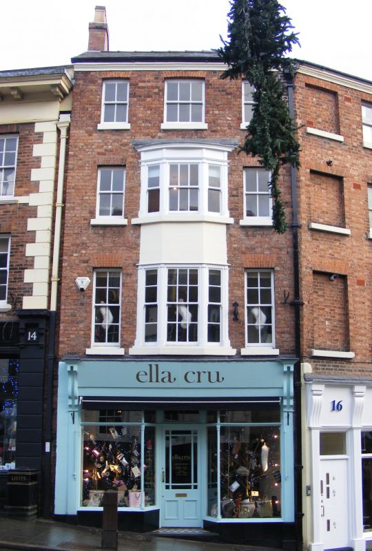
Entry Name: 15, Wyle Cop
Listing Date: 19 September 1972
Grade: II
Source: Historic England
Source ID: 1254944
English Heritage Legacy ID: 458413
ID on this website: 101254944
Location: Shrewsbury, Shropshire, SY1
County: Shropshire
Civil Parish: Shrewsbury
Built-Up Area: Shrewsbury
Traditional County: Shropshire
Lieutenancy Area (Ceremonial County): Shropshire
Church of England Parish: Shrewsbury St Chad
Church of England Diocese: Lichfield
Tagged with: Building
SHREWSBURY
SJ4912SW WYLE COP
653-1/15/705 (North side)
19/09/72 No.15
GV II
Shop. Early-mid C19. Brick with Welsh slate roof. 4 storeys,
3-window range. Plain early C20 shop front, and tripartite
canted oriel window flanked by 8-pane sashes with flat-arched
gauged brick heads above. Moulded wood eaves cornice. Gable
end stacks.
Listing NGR: SJ4935912358
External links are from the relevant listing authority and, where applicable, Wikidata. Wikidata IDs may be related buildings as well as this specific building. If you want to add or update a link, you will need to do so by editing the Wikidata entry.


Other nearby listed buildings
