Approximate Location Map
Large Map »
Latitude: 53.7944 / 53°47'39"N
Longitude: -1.5345 / 1°32'4"W
OS Eastings: 430763
OS Northings: 433221
OS Grid: SE307332
Mapcode National: GBR BLM.YL
Mapcode Global: WHC9D.DWJJ
Plus Code: 9C5WQFV8+Q6
Entry Name: The Chandlers
Listing Date: 11 September 1996
Grade: II
Source: Historic England
Source ID: 1255931
English Heritage Legacy ID: 465460
ID on this website: 101255931
Location: Steander, Leeds, West Yorkshire, LS2
County: Leeds
Electoral Ward/Division: City and Hunslet
Parish: Non Civil Parish
Built-Up Area: Leeds
Traditional County: Yorkshire
Lieutenancy Area (Ceremonial County): West Yorkshire
Church of England Parish: Leeds City
Church of England Diocese: Leeds
Tagged with: Building
LEEDS
SE3033SE THE CALLS
714-1/79/383 (South side)
Nos.90-134 AND 99-109 (Consecutive)
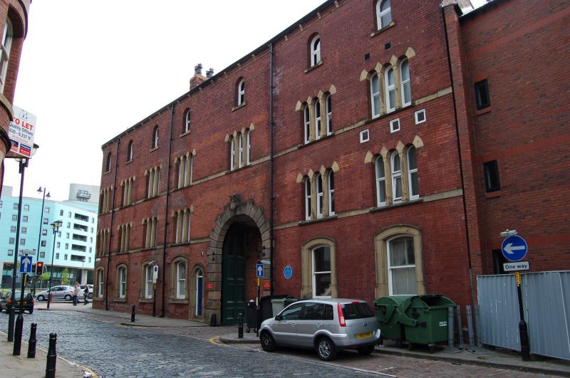
The Chandler's
GV II
Formerly known as: No.64 THE CALLS.
Mills, now flats. 1876, converted c1985. For William Turton.
Red brick, stone dressings, slate roof.
4 storeys and basement, corner site with 10 first-floor
windows to Crown Point Road and 6 to The Calls: triplet
windows and sill band to first and 2nd floors, round-arched
windows to top storey, small square openings, altered, to
ground floor, Crown Point Road, cambered lintels to
architraves on The Calls facade.
Corner pedestrian entrance: panelled double doors in stone
round-arched surround, raised lettering: 'WILLIAM TURTON',
carved impost blocks and keystone; above first-floor window:
'ESTD. WT 1844', above first floor: 'REBUILT 1876'. Arched
entrance to yard from The Calls has rusticated voussoirs and a
horse's head carved on the keystone; panelled double doors.
Courtyard: a tower reputed to contain a spiral stair and with
an ornate iron railing to viewing platform, possibly a former
chimney flue, against the Crown Point block.
INTERIOR: not inspected.
HISTORICAL NOTE: the building was a store for horse feed at a
time when horses were vital to the businesses which had to
transport goods to and from the railway termini; William
Turton had other interests in horse transport: he was Chairman
of the Bradford Tramway and Omnibus Co., and the Leeds Tramway
Co., and was a coal merchant during the later C19. The site at
Crown Point Bridge (qv), built 1840, is on the important wharf
of that date; products arriving by boat were unloaded into the
rear yard and after processing, carried through the entrance
on The Calls for distribution. The viewing platform would have
commanded a good view of traffic on the river and the Leeds
and Liverpool Canal. Said to contain stabling on ground
floor/basement.
(Hatcher, J: The Industrial Architecture of North Yorkshire:
1985-: 122; Yorkshire Archaeological Society Industrial
Archaeology Section: Eye on the Aire Report; Chandlers
Warehouse, Crown Point Road).
Listing NGR: SE3074933197
External links are from the relevant listing authority and, where applicable, Wikidata. Wikidata IDs may be related buildings as well as this specific building. If you want to add or update a link, you will need to do so by editing the Wikidata entry.


Other nearby listed buildings
