Approximate Location Map
Large Map »
Latitude: 53.9694 / 53°58'9"N
Longitude: -1.1 / 1°6'0"W
OS Eastings: 459134
OS Northings: 452961
OS Grid: SE591529
Mapcode National: GBR NQRJ.NV
Mapcode Global: WHFC3.2HGC
Plus Code: 9C5WXV9X+PX
Entry Name: The White House
Listing Date: 24 June 1983
Last Amended: 14 March 1997
Grade: II
Source: Historic England
Source ID: 1256263
English Heritage Legacy ID: 465113
Also known as: 28 Water End, York
ID on this website: 101256263
Location: York, North Yorkshire, YO30
County: York
Electoral Ward/Division: Rawcliffe & Clifton Without
Parish: Non Civil Parish
Built-Up Area: York
Traditional County: Yorkshire
Lieutenancy Area (Ceremonial County): North Yorkshire
Church of England Parish: Clifton St Philip and St James
Church of England Diocese: York
Tagged with: House
YORK
SE5952NW WATER END
1112-1/6/1179 (North West side)
24/06/83 No.28
The White House
(Formerly Listed as:
WATER END
No.28
Green Tree Cottage)
II
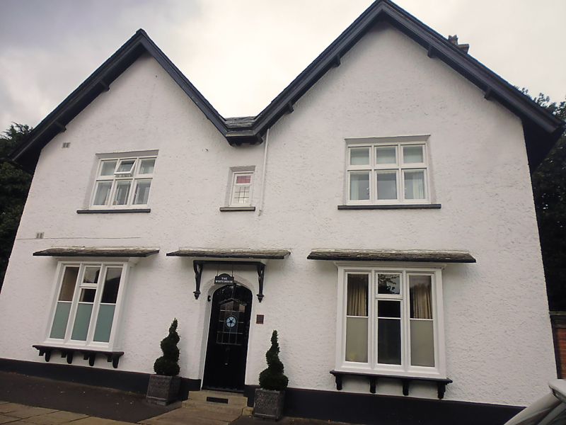
Public house, now house. Early C19, altered C20. Painted
roughcast with exposed brick side walls. Slate M-roof, with 2
gables facing road.
EXTERIOR: 2 storeys. 2 main bays, with one below each gable.
The ground-floor windows project on timber brackets and have
slated pentices. They are of 3 lights with timber mullions.
The main 1st floor windows are of 3 lights with a transom and
have casements. In the centre there is a small casement
window. The central doorway has a roughcast chamfered
Tudor-arched surround, and a slated pentice on shaped timber
brackets. The door is partly glazed. The gable verges project.
Chimneys to left and right, with tall partly-rendered caps.
History.
INTERIOR: not inspected.
The building was called the Green Tree in 1830 and kept by
George Holgate. In 1836 it was called the Sycamore Inn and
kept by Alice Holgate.
(An Inventory of the Historical Monuments of the City of York:
RCHME: Outside the City Walls East of the Ouse: HMSO: 1975-:
68).
Listing NGR: SE5913452961
External links are from the relevant listing authority and, where applicable, Wikidata. Wikidata IDs may be related buildings as well as this specific building. If you want to add or update a link, you will need to do so by editing the Wikidata entry.


Other nearby listed buildings
