Approximate Location Map
Large Map »
Latitude: 53.9673 / 53°58'2"N
Longitude: -1.1 / 1°5'59"W
OS Eastings: 459140
OS Northings: 452733
OS Grid: SE591527
Mapcode National: GBR NQRK.NL
Mapcode Global: WHFC3.2JGY
Plus Code: 9C5WXW82+W2
Entry Name: St Hildas Garth
Listing Date: 24 June 1983
Grade: II
Source: Historic England
Source ID: 1257010
English Heritage Legacy ID: 464307
Also known as: Clifton Holme
ID on this website: 101257010
Location: York, North Yorkshire, YO30
County: York
Electoral Ward/Division: Clifton
Parish: Non Civil Parish
Built-Up Area: York
Traditional County: Yorkshire
Lieutenancy Area (Ceremonial County): North Yorkshire
Church of England Parish: Clifton St Philip and St James
Church of England Diocese: York
Tagged with: House
YORK
SE5952NW OUSECLIFFE GARDENS
1112-1/6/821 St Hilda's Garth
24/06/83
II
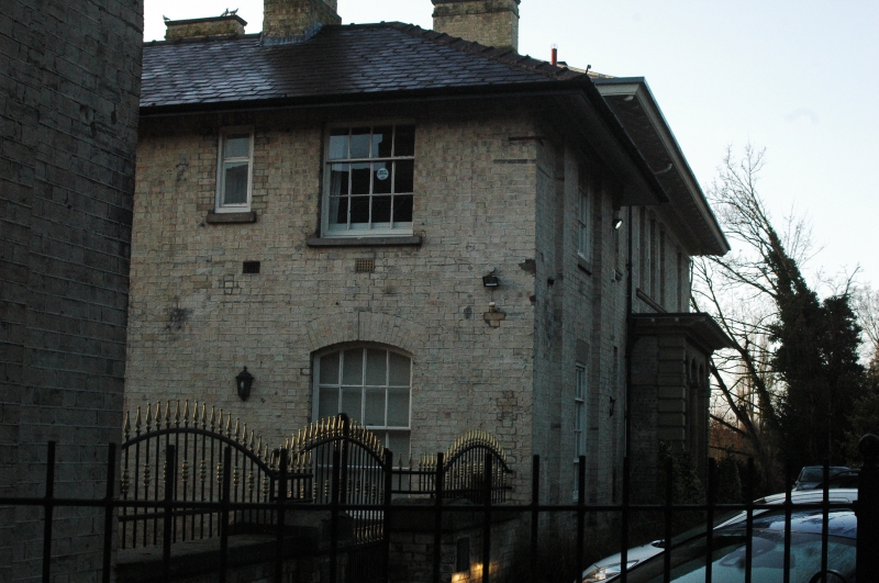
House, now Family Resource Centre. Built in 1848 for Joseph
Munby (solicitor). Yellow brick with stone dressings. Hipped
slate roof.
EXTERIOR: main block symmetrical, of 2 storeys with a 3-bay
porch and one bay to each side. The windows are glazing bar
sashes. The ground-floor windows of the outer bays have stone
panels below their sills. The central window above the porch
is blind. At the far left there is a small inserted 1st floor
window. The wide ashlar porch has 2 Tuscan columns in antis
supporting raised segmental arches. Within the porch there are
2 sashed windows with segmental heads, flanking a doorway with
a divided 4-panel door and an overlight with segmental top.
The eaves are coved and sprocketed. Chimneys to left and right
of centre in front of ridge. At the left there is a one-bay
2-storey link to a servants' wing. The front wall of this wing
is of one bay, flanked by pilaster strips and with pivoting
windows with glazing bars.
INTERIOR: not inspected.
(An Inventory of the Historical Monuments of the City of York:
RCHME: Outside the City Walls East of the Ouse: HMSO: 1975-:
69).
Listing NGR: SE5914052733
External links are from the relevant listing authority and, where applicable, Wikidata. Wikidata IDs may be related buildings as well as this specific building. If you want to add or update a link, you will need to do so by editing the Wikidata entry.


Other nearby listed buildings
